Monday, June 30, 2014

Blue Goose ~ Day 28

June 28, 2014 ~ Kennewick, WA to Suunyside, WA

I read a book a year or so ago about Richland, WA. It was Plutopia by Kate Brown, subtitled Nuclear Families, Atomic Cities and the the Great Soviet and American Plutonium Disasters. And Andree worked for a lawyer one summer reading depositions of participants in a group legal action seeking redress for radioactive pollution and resultant thyroid cancers. All this history intrigues me, but it might not be all that interesting to you so scroll down if you want...

NSNEWSNETWORK.ORG

In southeast Washington, and in southern Russia there are two atomic cities a world apart but with surprising similarities. The new book “Plutopia” studies the cities of Richland, Wash. and Ozersk, Russia. Both places made plutonium for nuclear bombs. And both sprung up from desolate places during WWII and the Cold War. Kate Brown says people who lived in Richland and Ozersk during the plutonium production days remember both towns as delightful places to live.
“Strangely enough
. Despite the fact that they are at the bull’s-eye of the Cold War in so many ways," says Brown. "They are vulnerable of attack from the enemy abroad, they are vulnerable to big explosions and they are vulnerable to sort of daily doses of low-levels of radiation.”
Brown says, sure, both the Russians and the Americans were dealing with some of the most toxic stuff on earth. But the governments made sure that most who came to work had secure jobs, there was plenty to eat and there were good schools for children...Brown says the urgency of war and limited resources also meant both the Americans and Russians disposed of waste harming the environment -- legacies that affected multiple generations in surrounding communities. Americans disposed of liquid and solid radioactive waste in pits in the desert sand, filled underground tanks with millions of gallons of radioactive waste, and sent more downstream in the Columbia River. In the late 1940s, the Russians filled their own underground tanks, sent thousands of curries of highly-radioactive waste downstream and sickening riverside communities.

“They didn’t tell any of the 28,000 people living downstream who didn’t have wells," Brown says. "They drank from those rivers, cooked with it, watered their livestock, watered their crops and ate the fish.”

Much of that waste both in Russia and near Richland has yet to be cleaned up...And in the American Northwest downwinders and atomic workers also suffered from poisoning from Hanford. 
WIKIPEDIA
The B Reactor (105-B) at Hanford was the first large-scale plutonium production reactor in the world. It was designed and built by DuPont based on an experimental design by Enrico Fermi, and originally operated at 250 megawatts (thermal)...Construction on B Reactor began in August 1943 and was completed just over a year later, on September 13, 1944. The reactor went critical in late September and, after overcoming nuclear poisoning, produced its first plutonium on November 6, 1944...This first batch of plutonium was refined in the 221-T plant from December 26, 1944, to February 2, 1945, and delivered to the Los Alamos laboratory in New Mexico on February 5, 1945.[32]

DAILYUW.COM (October of 2013)

Hanford is the largest superfund site in the country, a consequence of decades of large-scale nuclear material refining efforts. Most of the physical facilities at Hanford have already been contained and buried on site, but there is much more work left to do, including the prevention of polluted groundwater from reaching the Columbia River...Hanford will eventually be cleaned up, and at the moment the danger that the site poses to the public is likely overstated, although contamination to the Columbia River is clearly a very serious concern. The federal government has promised to make Hanford and the Tri-Cities a safe region, and it will make good on that promise, eventually.
The time estimates for completely cleaning up Hanford extend well into the mid-21st century, which is a shame. The centerpiece of the effort is a waste treatment plant to be used for vitrification, a process of encapsulating waste in contamination-resistant glass. It should have been built by now, and because it is still not complete, the work it is meant to do is being delayed decades into the future.


There are tours of the Reactor B site which I declined. In 2000, President Clinton designated all of this as a National Monument, albeit one with limited public access. Within the Hanford Reach is Saddle Mountain NWR. That is my point here.

WIDIPEDIA
The Hanford Reach National Monument is a National Monument in the U.S. State of Washington. It was created in 2000, mostly from the former security buffer surrounding the Hanford Nuclear Reservation (Hanford Site). The area has been untouched by development or agriculture since 1943.
The monument is named after the Hanford Reach, the last non-tidal, free-flowing section of the Columbia River in the United States, and is one of only two National Monuments administered by the U. S. Fish and Wildlife Service. President Bill Clinton established the monument by presidential decree in 2000...
Ancestors of the Wanapum People, Yakama Nation, Confederated Tribes of the Colville, Confederated Tribes of the Umatilla Reservation and the Nez Perce used the land for hunting and resource collecting...Geographically, the area is part of the Columbia River Plateau, formed by basalt lava flows and water erosion. The shrub-steppe landscape is harsh and dry, receiving between 5 and 10 inches (250 mm) of rain per year. The sagebrush-bitterbrush-bunchgrass lands are home to a wide variety of plants and animals, and the Hanford Reach provides one of the Northwest's best salmon spawning grounds. Forty-eight rare, threatened, or endangered animal species have found refuge on the monument, as well as several insect species found nowhere else in the world.[2] 

This is what the area looks like:
Hanford Reach National Monument - WA

Hanford Reach National Monument with the Columbia River and Reactor B in the distance - WA
Saddle Mountain NWR is included in the Hanford Reach but is closed to the public at this time; however when deemed "safe" by the DOE, it will be opened again, the point being I could only see it from a distance. There are some parts of the Reach, south of the river and nearer to Richland, that are open for public use, but this is formidable country what with rattlesnakes, heat, lurking / leaking radioactive material and the fluctuating water levels of the Columbia. And why exactly it this called a "reach" and why exactly did Clinton make it a National Monument?

If this interests anyone in any way, read Plutopia.

By mid afternoon, I was on the Columbia NWR, west of the town of Othello, which had an odd odor, like a kitchen in a cheap greasy-food restaurant.


The refuge had lakes, including Soda Lake and isolated rock cliffs (drumhellers), all in a shrub-steppe landscape (defined as open areas with sagebrush).
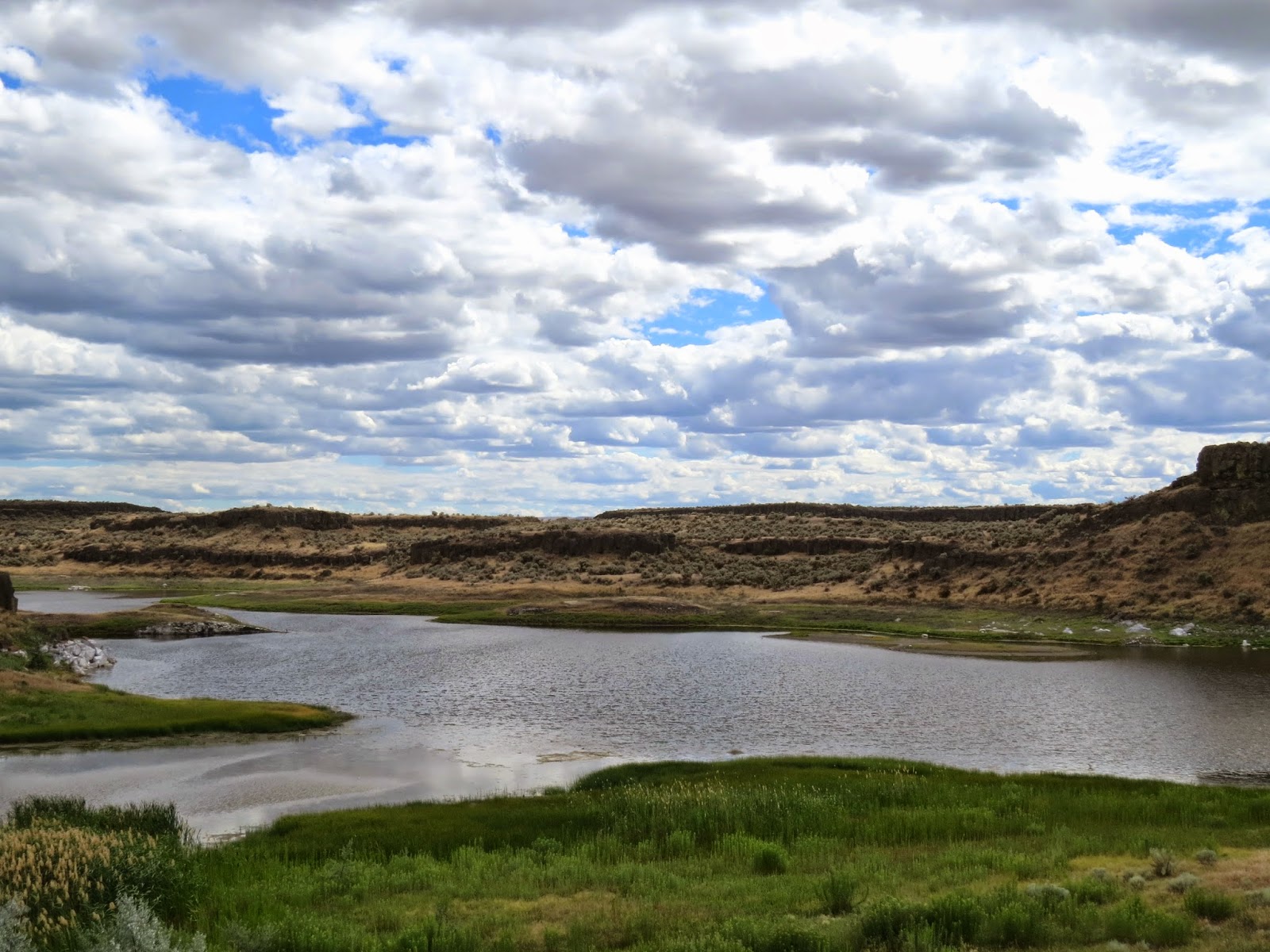
Soda Lake at Columbia NWR - WA
I find it interesting to drive along and see how the land has been changed by humans and then enter a refuge and see what is was. Not always as there often is extensive and ongoing management on refuge lands, but there isn't much obvious human disruption...a few roads, some fencing, discrete interpretive signs and primitive day use areas...
Birdwatchers at Soda Lake - Columbia NWR - WA

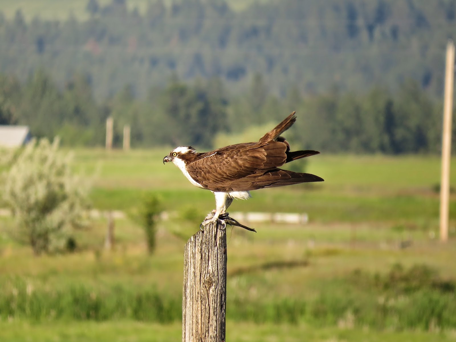
I failed at watchful waiting here. I got to about 20 minutes and moved on. I did not see either Rock or Canyon Wrens that use this habitat. What I do see everyday though (besides Robins and Common Yellowthroats) are Northern Harriers, hawks with white rumps which fly low over the fields cruising for food.

Checking where to go next, I decided on Toppenish NWR  which was southwest, so retraced my route of earlier today for 40 miles and drove another 40 miles south and west to Sunnyside, WA, near which there was a cultivated crop with a sweet minty fragrance. Agriculture is big all through this area, especially veggies, fruit and vineyards. There is a significant Hispanic culture here with bilingual signs, Mexican restaurants and Spanish-speaking employees in the stores. Irrigation with elaborate delivery systems turns the brown fields green. I was reminded of The Milagro Beanfield War.  

I found a spot under a shade tree at a busy Walmart. What did I eat for dinner? Cheese and crackers, pickled herring, a glass of wine and some bite-size Milky Way pieces.

I am forcing myself to read 15 pages a day of Look Homeward Angel by Thomas Wolfe, which I've been reading for five years, but so intermittently that I can't remember where I left off months earlier and am probably re-reading several chapters. It is too florid in places for my taste and could be cut by one-third. Still, I understand why it is a classic. Are all of Eugene's (Wolfe's) high strung emotions that important for the story?

Sunday, June 29, 2014

Blue Goose ~ Day 27

June 27, 2014 ~ Colville, WA to Kennewick, WA.
There were huge containers of watermelons in front of the Walmart, like hundreds. I had the bathroom to myself, and since no one was at any of the cash registers, I left without making the token purchase of appreciation, like ice or water. 

It was overcast and drizzling on the hour-long drive south to Spokane.
Between Colville and Spokane, WA
The evergreens in the northwest impress me anew each time I see them again; they are truly magnificent, and one can drive for hours through various state and national forests. The species vary with elevation, but there are only a dozen or so common ones: spruces, firs, pines, hemlocks and larches (the only 
evergreen to lose its needles in the fall). It’s unsettling to see unconscionable logging which one does see occasionally. I am certain clear-cut logging is still done, just not as often where visible from major routes. It isn’t only the scrap left behind and the barren mountainsides but also the switchback roads built for trucks to access and remove the timber, so it is heartening to pick up literature at the refuges and realize how many organizations and groups are working to preserve natural landscapes, with the restoration of wetlands a huge initiative, along with providing safe places for threatened and endangered species of both flora and fauna. The first white settlers always messed with water to mitigate flooding, for agricultural purposes and to more easily provide water for cattle and horses. In so doing, wetland habitat was destroyed. So far, one of the main management tasks is restoration.

I made the daily Starbucks stop on the north side of Spokane and then headed to Turnbull NWR 10 miles west, near the town of Cheney. The sun was still not shining and my mood also never is as bright on a dull damp day like today. At first this refuge was silent; very few birds, although I did spot a pair of Mountain Chickadees flitting high up in a Ponderosa. Also, there was no one visible at the refuge office. Usually when I walk in, someone appears and is willing to answer any questions, always helpful. I drove through the refuge and then decided to walk a mile trail which helped my mood and made the visit more memorable. 
Turnbull NWR - WA
There was a family group starting out when I did. I couldn’t quite figure out how they were connected. There were two gentleman about my age, who conversed quietly as they moved along, a couple of older women, and a extroverted young man with shorts, long dark hair and high tops with no socks who seemed to be into the hike. A young woman with long blond hair and a red jacket stayed behind and filed her nails. The adults were a type one sees traveling out west: dressed in casual but well worn LLBean or Patagonia, with intelligent demeanors; the women wear no makeup and have greying medium length hair; they are physically fit, vocal but not obnoxious, inquisitive….I liked that there were other people finally. When Esther asked if I missed talking to anyone, I thought about that and don't miss talking, but do like to have limited people exposure, and nonverbal is fine. Often I see no one at the refuges, especially after hours or on weekends. 

I had hoped for a White-headed Woodpecker. No luck though. The trail I walked was a loop around wetlands, and I pished a Common Yellowthroat for a very brief glance before it disappeared again in the reeds. There was definitely more activity than in the dry uplands here, and I am sure there are all kinds of birds, just not as evident on this chilly, cloudy June day. 

Are you all tired of hearing about Starbucks? Well, I knew there was one just off I90 at Rtizville, WA, which is unusual as this stop is really just a generic interstate exit with a couple of gas stations / convenience stores and a motel. But it also has a Starbucks which was more crowded than any I’ve ever been in, and very efficient. Although the line stretched nearly to the door, I had hardly any wait, just long enough to eat half of a large Rice-Krispy cookie. I really do need to get this immediate gratification junk food deal under control. But it was delicious, the sun came out and the road to Kennewick, WA was smooth and fast. And, pleasant surprise: the Priceline motel was a Hilton Garden Inn. 

I worked, but had computer issues so went down to the bar and had the best veggie quesadilla, a glass of wine and chatted with the waitress and bar patrons…one man was reading a  book by Jim Bouton and another was ordering $14 drinks made with Grey Goose vodka. There were lots of young girls and their parents staying here for a soccer deal. A huge difference from my motel in Williston last Friday. Such is the Priceline way I guess. 


Of course I slept very well but only had four pillows this time. 

Blue Goose ~ Day 26

June 26, 2014 ~ Bonner’s Ferry, ID to Colville, WA
The Kootenai NWR is 6 miles from Bonner’s Ferry. I was there before 0700, poking around near the headquarters. There were beautiful flowers blooming, especially a large patch of columbine. 

A sign showed the trail to Myrtle Falls starting at the parking lot. I had come to the land of gigantic trees, reminding me of Oregon. As the trail entered the forest, it went from light to dark, almost like a tunnel. The canopy cuts off most light but there isn’t dense underbrush beneath these huge trees, rather in this area, a soft carpet of light brown pine needles. I crossed a river over white water (which I thought were the falls) and went on a bit further but had no idea where the trail went or how long it was. Later, I was told that I needed to go further to actually see the falls and that it was only a quarter-mile.  The falls were thundering between cliffs of rock…serious non-navigable water, wild and spectacular of course. Dozens of wildflowers were near the this trail. I met a family from Florida with three kids. We all saw the falls, took some photos and left, glad to have made the slight effort. The river is Myrtle Creek which soon flows into the Kootenai and the impressive falls speaks of the varied habitat - mountains and wetland valleys. 

Back at the Visitor Center, I noticed hummingbirds constantly sipping from two feeders close to office windows. There were three species: Blackchinned,, Calliope (probably my favorite bird name), and Rufous. I took about 60 photos, putting the new Canon to the test.
Calliope Hummingbird at Kootenai NWR - ID

Rufous Hummingbird at Kootenai NWR - ID

Black-chinned Hummingbird at Kootenai NWR - ID


I drove the auto route around wetlands and later went up Lion’s Den road hoping to see a MacGillivray’s Warbler. The woman in the office told me that they had last been reported there. I didn’t see a warbler but saw a Blue-headed Vireo, except when I checked the field guidd, the range was wrong for that bird, but was right for Cassin’s Vireo which looks almost exactly like a Blue-headed. Another life bird!

Kootenai was a beautiful refuge, close to town, open early. I walked the Chickadee Trail seeing only a Red-Breasted Nuthatch. Many species have either moved on to more northern nesting sites or are busy brooding and feeding young. There just isn’t the frenzy of April and May. 

After spending a couple of hours, I left and drove south to Sand Point, ID, where I found a Starbucks, badly in need of caffeine as I was sleepy, and then went west and north and west again to Little Pend Oreille NWR near Colville, WA. The route north was along the west back of the Priest River and through national forests and occasional small resorts. It felt like northern Michigan. I stopped in Usk and, since I had no cash and didn’t want to use a debit card for a bottle of water, I bought zuzu food, like jelly beans and cheese and pepper potato chips and two bottled Frappucinos. I ate half the chips (not that good) and threw the rest out the window so I wouldn’t be tempted later. I then started in on the jelly beans (you know, salty, then craving something sweet, or just boredom) and finally began throwing the white and yellow ones out the window, feeling like Hansel and Gretel. I also had had a Michigan Cherry bar at Starbucks earlier. The day was a nutritional disaster. 

It rained intermittently but would clear in between showers. I got to Little Pend Oreille after it had closed but drove the auto route. Nearly all refuges are open sunrise to sunset; it's just the offices that usually close at 4 p.m. This was a large refuge and is consumptive in that people hunt, fish, ride horses, log and even camp. The road started out well marked, but then I found myself getting deeper and deeper into the refuge, and the road got more and more marginal - narrower, rockier, ruttier, muddier. I went past a logging operation, although no one was there, continued on but finally turned around. The map I had didn't help enough. I had passed a campground with several RVs and horse trailers earlier and almost turned in, thinking how cool it would be to sleep on a refuge since most do not allow that. But I didn’t, thinking that perhaps this was a group of people who all knew each other, and I would be crashing their party. I was not really apprehensive about checking it out; more just ambivalent / lazy. 

I got back on the designated auto route and decided to spend an hour under the Ponderosas. It was a very quiet hour with only a few distant twitterings of birds and no animals, not even squirrels. It was savannah-like under the trees, and I could sense the light slowly fading in the west. I knew I was quite near one of the exits, and that Colville (where I planned to stay) wasn’t far. 

Total quiet: no wind in the trees, no insects buzzing, no squirrels or marmots or chipmunks chattering. One pickup passed in the hour I was there. I find if I can resist looking at the timer until it is past 30 minutes, I am then on the downside of the hour and gets easier. Not that this exercise is unbearable, but it is kind of a meditation which I never do. The success is directly proportional to the choice of venue. This spot was marginal in that “nothing” was happening. It’s harder than I thought it would be to do nothing for an hour. It is something Maria would have been good at. Planning things is often more fun than executing them. But I am adding to my memory bank…..an hour on a June evening in a Ponderosa forest will be more pleasant in retrospect than actuality. 


I got to the Walmart in Colville and drove slowly around the parking lot before picking out a spot. Often I change positions if something looks better once I settle in.
Logging - Colville, WA
Directly across the highway was a logging operation with an immense machine that was several stories high with claw-like pincers that would pick up a dozen or so logs from gigantic piles, move down a track and drop them. Bright lights illuminated the yard. I don’t know if they worked all night but were at it early the next morning.

And a street sweeper type vehicle was careening round the parking lot of Walmart, madly sweeping and cleaning. It passed very near my van about five times but finally retired for the night. And then it began to rain hard; I was secure and sleepy and actually liked the sound of raindrops, although I had to completely close the windows. 

Friday, June 27, 2014

Blue Goose ~ Day 25

June 25 ~ Polson, MT to Bonner's Ferry, ID

I slept in, waking at 0630.  I cleaned up (relatively) in Walmart, bought ice and drove to the Starbucks in Kalispell, 50 miles north. Kalispell gets busier each time I return. There is now a Cabela’s next to Starbucks. The commercial interests sprawl south for miles, but not as much to the north where I went to a little shop in Whitefish called Sage and Cedar to pick up essential oils for Ginny. Whitefish is one of those attractive little towns where tourists amble up and down the two-block downtown spending money on discretionary items. It's well situated with  Glacier National Park just to the east and Whitefish Mountain Ski Resort visible to the north. Containers and hanging pots were full of flowers and small trees. The handsome two-story Amtrak station is also downtown, as well as the O'Shaughnessy Center for the Performing Arts. And the hospital just south of town even has a resort-like ambience. I was reminded of that when I drove by,  remembering how Maria, who had taken the train out to help me move once again, ended up there overnight after getting dehydrated on the train, and how upsetting it was to see her so sick. But she, at that point, just needed a night in this luxury hospital, and we had a wonderful trip driving back to Michigan. I do remember her saying that a head CT was clear...no evident metastases at that time. 

I drove the back roads through my old neighborhood. Canola, the current popular crop, was in flower with striking bright yellow fields.

Canola in MT
When I first came to the Valley, it was mint which gave the air a lovely 
scent on summer evenings. 

I did not stop and see my friends although I thought of them all - Loretta, Lori Bell, Nancy, Kelly, Sara, Joey, Joanie.... I need to get to Eugene by the July 4th weekend and had to push on. Which I did to the Lost Trail NWR, a place I never knew about all those years I moved back and forth between Montana and Michigan. 

The directions in my refuge book mentioned going over “Haskell Pass” on a gravel road and I wondered about that. I still had 12 more miles to go when the road got sketchy with steep drop-offs and no barriers. I was asking myself if I really wanted to do this and said no, but continued anyway, and very soon got over the pass with an easy drive the rest of the way. But I would have to return, with the drop-off my my side of the road, so that was a niggle in the back of my mind. The saving grace was that it really was only a short distance. 

I found the refuge office situated in an open prairie / meadow habitat and talked with an articulate knowledgeable woman who told me about the restoration of Dahl Lake. Historically, the refuge had been a huge horse / cattle ranch, and water was managed to benefit the ranch with more than half of the wetland habitat destroyed. An interesting series of events finally resulted in the purchase of this land, now over 9000 acres, and it's designation as a NWR 15 years ago which was: The Montana Power Company, who owns Kerr Dam at the south end of Flathead Lake, manipulated the water levels of lake. When they were raised, the wetlands at the north end of the lake were lost, and there was also water encroachment onto private property. Eventually, the the power company had to pay out tons of money. As part of the legal mitigation settlement, Lost Trail was purchased. One of the management priorities consists of restoring Dahl Lake. So far, it has tripled in size attracting water fowl. The Boreal Toad, a "species of concern" also lives here. The habitat of the refuge overall is varied with an impressive list of birds. The manager and her husband live in a wonderful old farmhouse adjacent to the offices, and she also continues working to protect the north Flathead Lake wetlands. 
Dahl Lake on Lost Trail NWR - MT
I found out, happily, that I didn’t have to go back over Haskell Pass but could get to US2 via Lost Prairie Road, where I stopped for an hour, under Ponderosas and larches, next to an extensive open meadow. I ate an avocado and grape tomato salad, listening to and seeing  Chipping Sparrows and a Warbling Vireo. One car passed me in an hour. It was just warm enough, sunny with very few insects and the air had that good western dry piney smell. 
Lost Prairie Road with resin dripping onto this notice - MT


Back on US2, I continued west to Bonner’s Ferry, Idaho, where I had to drive around some to find a spot to stay, but then spotted a Super 1 (grocery store), open 24 hours and saw no signs warning about “Cars Will Be Towed at Owner’s Expense” as did the Safeway just down the street. I wish I had checked out a Forest Service campground west of Libby where the Yaak River flows into the Kootenai but went past it too fast. It would have been a good spot. The Kootenai is a pretty milky jade green with fast flowing water, although nothing like it was before the dam at Libby which created Lake Koocanusa. This river's headwaters are in British Columbia. It then flows south into Montana and Idaho before turning north again, eventually emptying into the Columbia River in BC. It is the second largest tributary of the Columbia. So this is the second river (the first was the Souris in North Dakota) that originates in Canada, flows south into the US for awhile before returning north back to Canada. 

For a brief period just as I was half asleep, there seemed to be a motorcycle contest in the parking lot for which one could make the most noise. But then everything quieted down

Thursday, June 26, 2014

Blue Goose ~ Day 24

June 24, 2014 ~ Missoula, MT to Polson, MT.

Jeez louise, Missoula is a busy town, but busy towns have coffee shops, and this was my first stop - a Starbucks on the south side of town, before heading 25 miles to the Florence / Stevensville area to one of the prettiest NWRs  yet, the Lee Metcalf NWR.
Lee Metcalf NWR - MT
Mr. Metcalf must have been an extraordinary man to have this refuge named after him. He was born in Stevensville, became a lawyer and then a US Senator with an impressive record of doing whatever he could for people and the environment. I will definitely read and learn more about him.

The Visitor Center was full of taxidermied specimens and skins and skulls, books, pamphlets, educational opportunities, and a friendly woman was answering questions and handing out loaner binoculars to a small group while I checked things out (trail maps, recent bird sightings or possible irresistible book purchases).

I walked two miles, accompanied by singing Common Yellowthroats the whole way, but seeing only one. Black-billed Magpies were ramming around raucously vocalizing and a Lewis's Woodpecker flew back and forth from the highest point of an old dead tree. Even though it was the middle of the day and much warmer than I expected, I saw flycatchers, swans, pelicans, ducks, waxwings, a Yellow Warbler and an osprey flew overheard.

The narrow trail wound through chest-high grasses in places, so I had Rocky Mountain Spotted fever on my mind (tick-borne disease). If I get it, I need doxycycline right away; that much I know now from googling. It's hard to diagnose and not a good thing to have. But I didn't see any ticks in my cursory checks.

I got overheated on the trail and drank a bottle of orange juice and lots of water when I was back in the parking lot and revived quickly, but I need to pay better attention to this, along with using sunscreen and wearing something on my head.

I have a cousin who lives in the hills above the refuge and debated whether to just stop by but didn't. Mostly I needed a long hot shower. "Hi Mark and Katie, Can I use your bathroom for an hour?" I was completely, totally sticky and gritty.

Should I just spend another night in Missoula? or continue to the National Bison Range. If I went on, I had to start the Red Sleep Drive through the range by 7 p.m. in order to be finished by gate-closing time, which I figured I could easily do.
National Bison Range - MT
I've been here several times; it's an 18-mile drive, and more than once on past visits, I had to slowly edge past massive bison or wait while they moved off the road. Remember, Steve and Andree, the time we went and right at the opening gate there was a huge bison looking at us with no apparent concern? However, in any human vs. bison encounter, the humans wouldn't have a chance. There are signs warning people to stay in their cars, and the bison must generally have placid dispositions. They could even do serious damage to a vehicle. I was here once in early spring when there were their reddish-colored calves all over and even then I didn't feel the parents were threatening. This time, although I rode past a large group of calves and adults a mile or so south of the range and confined in a pasture, I only saw a few adults on this particular drive and one elk. Red Sleep Drive has seriously steep switchback grades, which seemed much steeper than I remembered, which I attributed to driving a Subaru versus a Dodge. I sit higher in the Dodge. Really, the down-hill  trip was mostly braking, trying not to get distracted by the incredible views of the Mission Mountains to the east.

There has been an ongoing discussion about whether or not the Confederated Salish and Kootenai Tribes (Flathead Indian Reservation) should also be included in the management of the bison range. As far as I could tell from a quick search, they are not currently involved but the issue is not resolved to their satisfaction. This is interesting in view of the what historically has happened to Native Americans.

There is a fascinating account of the origin of the bison on the NBR at: www.bluegoosealliance.org/info/origins-foundingbison-nbr.pdf.

With a couple of hours of daylight left, I went to Ninepipe / Pablo NWR, another expanse of wetlands and hundreds of small glacial lakes. This refuge is on the Flathead Indian Reservation, and I think the Salish / Kootenai Tribes are involved to some degree in its management. Since I drove US 93 last, there are new signs along the road in both English and Salish, an animal bridge over this busy highway (Missoula to Kalispell) and a new divided road through the small town of Arlee on the reservation.

I had to find some roads in the refuge on my phone; there were only a few, but I stopped on the side of one of them and immediately saw an Osprey perched on a  post right in front of me, chocolate brown with white belly and head.
Osprey at Ninepipe NWR - MT
It flew after a few minutes with prey in its talons. For most of the hour I sat by the marsh, a Great Blue Heron moved zen-like through the reeds nearby while other herons flew in the distance. When I was about to leave, I looked behind me and saw a large dark bird perched in a tree top in the distance. I was almost too lazy to get my scope out and tried convincing myself it was a Swainson’s Hawk, but when I focused, it was a Golden Eagle, a bird I haven’t seen for a couple of years. So my watching hour had this perfect raptor beginning and ending.


As day gave way to night, I drove to Polson, found a brand new and upscale Walmart and stayed there. 


Wednesday, June 25, 2014

Blue Goose ~ Day 23

June 23, 2014 ~ Lewiston, MT to Missoula, MT

This morning I found Beans 'n Things in downtown Lewiston and sat there a couple of hours, drinking an Americano and later eating a delicious breakfast panini of scrambled eggs, thick crisp bacon and cheese.

I had some errands to do, like getting the oil changed, which was another nice surprise as it took less than 15 minutes. I faxed some insurance papers at the local Albertson's (grocery store), got ice and a few groceries and mailed postcards.

Lewiston (at least based on the past 18 hours) would be on a short list of places I could live. It's surrounded by mountains in the distance, so the feeling is openness and big sky which was a rich blue this morning. The town seems solid, well maintained and prosperous in a non-ostentatious way. There are the requisite businesses and commercial establishments but they don't sprawl far from the city proper, and on this perfectly glorious June morning, it was an attractive, inviting place.

I drove west and slightly north to Great Falls, a busy congested town with Malmstrom Air Force base but also with the impressive Charles Russell Museum. I have been there and was tempted to stop again but didn't want to spend money, which I most surely would have. Like on jewelry or prints or books.

WIDIPEDIA
Malmstrom AFB is one of three US Air Force Bases that maintains and operates theMinuteman III intercontinental ballistic missile...Originally named Great Falls Army Air Base, later Great Falls Air Force Base, the facility was renamed Malmstrom Air Force Base on 1 October 1955 in honor of Colonel Einar Axel Malmstrom (1907–1954). Colonel Malmstrom, shot down on his 58th combat fighter mission in World War II, became the US commander of Luftwaffe Stalag Luft 1 South Compound, at BarthGermany. After his release and return to active Air Force service, he died in the crash of a T-33 Shooting Star trainer on 21 August 1954 near Great Falls Air Force Base. In the short period of his tenure as vice wing commander, Colonel Malmstrom endeared himself to the local community. Saddened by the loss, the people of Great Falls began a drive to rename the base after him.

Lake Benton NWR is 15 miles north of Great Falls. Suddenly I was up on the high plains again, away from the river valley, and wondering exactly where this refuge was. Google and my refuge book weren't that helpful, but the iPhone came through....again. It really wasn't all that tucked away, but some of the refuges don't have Visitor Centers, and while I saw Benton Lake NWR signs, I wanted to find an auto route in the refuge. I was too impatient because once again I only drove a bit farther and found it, stopping at the entrance kiosk to get information, and then making a brief stop at the VC. I asked a woman about the GS (General Service) status of employees at the refuges and she said everyone "except maintenance" had a GS status, adding "I'm a GS."

WWW.MILITARY.COM
Cracking the GS code.The coding systems used to classify jobs vary by agency, but the most common system is the General Schedule (GS). The GS assigns every job a grade level from 1 to 15, according to the minimum level of education and experience its workers need. Jobs that require no experience or education are graded a GS-1, for example. Jobs that require a bachelor’s degree and no experience are graded a GS-5 or GS-7, depending on an applicant’s academic credentials and an agency’s policies. The table below shows the GS levels for entry-level workers with different amounts of education and little or no work experience.

I wondered if President Obama is GS-15.

The refuge was once a shallow lake and is flat with marshes surrounded by the auto route.
Benton Lake NWR - MT

The coolest sighting here was 100s of Wilson's Phalaropes, one of the few bird species in which the female is more brightly colored than the males. Or maybe the coolest and most unexpected sighting was another good look at a Sprague's Pipit, standing in the road at the far end of the marsh. The mosquitoes were abundant, and I kept opening and closing windows and squashing those that got in the van.

Benton Lake is wetlands and shortgrass prairie habitat. It was / is a shallow leftover glacial lake.

Prairies are classified as Tallgrass, Mixed or Shortgrass and are found in the states in the middle of our country from north to south. The grasses get shorter as one travels west. The states with Mixed Grass prairies are North and South Dakota, Nebraska, Kansas and northern Texas. Tallgrass prairies are east of these states covering most of Iowa and Illinois (or did historically) and don't penetrate as far south as Mixed or Shortgrass. Shortgrass prairies are in the west, including most of Montana, the eastern halves of Wyoming, Colorado and Texas. Just in case you wanted to know....

AND if you also want to know what a forb is, as I did, the dictionary says it is a "herbaceous flowering plant other than a grass." I had heard the word "forbs" used by refuge people when they talked about grassland management. Benton Lake seemed not to have a variety of either grasses or forbs compared to the ND refuges, but that is probably due to less rainfall.

I had decided to stay in Lincoln so drove MT 200 west, a spectacular route of mountains, rangeland, an occasional herd of black cows and the thin strip of highway ascending and descending long, long grades, all under what is aptly called the big sky. This was a storm to the north. Seldom is the sky uniformly grey and bleak.

MT 200 between Great Falls and Lewiston

I weakened in Lincoln and had dinner at the Montanan Steak House which I knew from previous visits and had a warm beef salad with corn, red peppers, thin tortilla strips, cheese, tomatoes cut in small cubes, little white beans and tender beef pieces with a crispy grilled exterior, all dressed with a spiced ranch. I ate the whole serving and then had warm pecan pie with vanilla ice cream. Almost every time I order desserts, I wish I hadn't but not tonight. The portion was modest and delicious. So, for anyone traveling through Lincoln who is the least bit hungry, stop for a treat. Plus, Lincoln is a small town with huge Ponderosas all over, espresso drive-throughs and The Three Bears, a cool little motel on the west end of town.

I drove through the city campground ($20 for "wet" camping and $10 for "dry") situated adjacent to a kids' baseball park with a summer's night game in progress but moved on due to some inner, undefined agenda and drove along the lovely Blackfoot River to Missoula - the Blackfoot River of A River Runs Through It fame.

On my map of the refuges, there is a Blackfoot River NWR but I couldn't find any further information, either on the Internet or in refuge guide.

The Walmart parking lot in Missoula had several RVs and I felt surrounded by fellow roadies. The next morning, there was even a small tent on the blacktop. That seemed weird, both since Walmart discourages any "spreading out" and also because who would want to sleep outside in any parking lot?

I watched fireworks from very nearby, all of which were exploding against a large grey cloud backdrop which was still visible as it is still so close to summer solstice with lingering daylight.


Tuesday, June 24, 2014

Blue Goose ~ Day 22

June 22, 2014 ~ Glasgow, MT to Lewiston, MT
The town was sleeping on this Sunday morning; even McDonald's didn't open for an hour ,so I got a bag of powdered mini donuts and coffee at a gas station after brushing my teeth. I kept adding products to make the coffee palatable…sugar, cream and then more of each. And throughout the day I ate the whole bag of 24 donuts. Yeah, pathetic, but I whenever I got the slightest hunger signal I reached into the open bag. I almost threw them out the window and should have, but they were much more tasty than I expected. 

My destination was Bowdoin NWR. I turned off US 2 on what I thought was a shorter route. I’ve done this several times and never quite remember which road I need, but with the iPhone I can easily find exactly where I am. I spent the first 90 minutes poking along the gravel roads before even getting into Bowdoin and immediately saw a Burrowing Owl on a fence post, utterly still and coolly staring back at me.
Burrowing Owl - near Bowdoin MWR - MT
And soon saw many more birds, including a Wilson’s Snipe, also perched and seemingly not bothered by my proximity. Then was a nondescript grayish-brown bird with big eyes that puzzled me until I saw two more cooperatively plucking grit in the road and realized they were Sprague Pipits, the skylarking bird of Lostwood that is seldom seen, though common in this part of the country. Pete Dunne says: “Uncommon, geographically restricted, habitat-specific, skulking, and really hard to find.” This was my second life bird of this trip. I figured the rest of the day would just be the frosting.

There was a large snake in the grass at the Visitor Center. I keep trying to develop a better attitude about snakes but have made no progress in that regard. Two gentlemen with binoculars were in a car in the parking lot looking at the trees around the center and, though they hadn’t seen it, thought it was probably a “bull snake.” I, of course, thought “rattler.”

Bowdoin was a refuge I visited for the first time with Maria, hoping for a Black-necked Stilt, and she almost immediately spotted one for me. We had left Ginny and Adam to hang around the
VC while we drove the 15-mile auto route through grasslands, along the shore of Lake Bowdoin and then through marshes, seeing most of the same birds I saw today. I thought of her with the sort of sad sweetness that comes over me with memories like this. The best bird I saw was a single Long-billed Curlew, but there were also many Marbled Godwits, one White-face Ibis, Wilson’s Phalaropes, Vesper, Grasshopper and Savannah Sparrows, a few BN Stilts, an American Avocet, ducks and grebes.... In the wetlands, the Marsh Wrens were very loudly scolding me as I drove by, sounding as though they were two feet away, but I didn’t see them and didn't wait for them to pop up. Or perhaps they were just singing on this fine June morning. I also saw my daily Common Yellowthroat. 


In Malta, I headed southeast to what is often referred to as the “jewel” in the NWR system, the Charles M. Russell NWR. I was starting to see blue-grey mountain ranges in the distance and, for a while, I skirted the Little Rockies, leaving ranch lands for modest hills and different flora, including evergreens. The refuge is huge - more than a million acres on both side of the Missouri River - 150 canoe miles, from the free-flowing upper part to the gigantic river / reservoir created by the Fort Peck Dam in the 1930s in eastern Montana. Ivan Doig's novel Bucking the Sun is a great story about the building of this gigantic dam. 

CMR NWR was stunning - much more beautiful than I expected. There was a sweet fragrance in the air as I drove through a landscape of yellow sweet clover, juniper and sage.

Charles M. Russell NWR - MT
Lewis and Clark traveled the Missouri so there were several informative signs, describing in their own words pretty much what I was seeing. Two-thirds of the auto route is high above the river and one-third in the bottoms where cottonwood fluff filled the air as it gently floated around. I just googled this and discovered that it is cottonwood seeds, and the fluff factor helps them float into habitat well away from the parent trees, since the cottonwood needs full sun to grow. The seeds "can't live in their own shade." Sort of like some kids. 

I continued through beautiful scenic country through the Judith Basin to Lewiston where I happened upon a local "Rest Area - Welcome Overnighters" on the top of the hill just west of town. What a sweet surprise. It is supported by local service organizations and businesses and donations from travelers. I drove through, saw a gentleman in a camp chair outside his RV reading, decided this was my kind of place, found a site under a tree. There were even clean and heated bathrooms. 

I spent the next hour looking throughout my entire van for the cable I needed to download photos from the new Canon to my computer. I did eventually find it, got settled with a glass of wine and spent two hours downloading and editing photos and writing. 

It got cold enough during the night that even under two blankets I was chilly when I woke up at 0445 as the temperature was in the 40s. I have a third blanket tucked under the cot that I can use if needed....or I may buy a good down sleeping bag and lighten my load. Too much stuff.....which made looking for the cable a process of removing and repacking just about everything in the van. In general though, other than always moving bags from one place to another, the cot has been just what I expected. I could put up the tent, but why??? when the process of getting the cot out of the car, setting up the tent and taking it down in any but totally perfect conditions is too much fuss. However, I do have that option. Also buying an ultra light-weight, high tech backpacker's cot is an option down the road.


Monday, June 23, 2014

Blue Goose ~ Day 21

June 21, 2014 ~ Williston, ND to Glasgow MT
Finally, I escaped into Montana and spent the afternoon on the Medicine Lake NWR, which is similar to Lostwood. When I first got there, I was pissed because the gate was closed to the headquarters and I made some calls, getting, of course, it being Saturday afteroon, recordings. I complained and said I would not have driven 50 miles round trip had I known the auto route wasn’t available and that such information should be on the website, feeling kind of tight ass about whining. Still, this would have been the second time I was at Medicine Lake with no access.  But since I was up there anyway, I thought I would explore the roads near the refuge and soon discovered that had I driven about 50 feet further I would have seen the auto route which was open, so I immediately called back and apologized to the voice recording. It was sunny but blowing hard. Still, with a hat and sunscreen, I stood with my scope for an hour, looking and listening for what is described as one of the "most common" birds on the refuge: the Baird's Sparrow, which I did hear at least once but never definitely saw.
Medicine Lake NWR - MT
I drove the rest of the auto route with Medicine Lake on my right. At the end were wetlands highlighted by the late afternoon sun and the usual marsh fauna.

Medicine Lake NWR - ND
Only occasionally do I see another car out on these refuges. I can understand why one probably has to be of a certain age to appreciate and need the solace of nature but it seems few people come. Maybe that will change as I move around 
the country.  

I am coming to understand that the refuges are extensively managed. On the specific and generic web sites, there are descriptions of what happens at each site. And there are often site-specific signs, either along the refuge roads or at the Visitor Centers describing the missions: why burning occurs for example, or why cattle graze or why water is impounded and drawn down. The National Wildlife Refuges are a part of the US Fish and Wildlife Service, so as noted before, one of the primary goals is to provide opportunities for hunters and fishermen, which does somehow seem counterintuitive to the "refuge” concept, but there are strict regulations regarding what, when and how certain abundant species may be taken. Ducks Unlimited contributes millions of dollars to help maintain this system. Protected and endangered species are isolated from the public although they also are managed in various ways which (one hopes) will give wildlife biologists more information towards a goal of preserving the species.  

It was 100 miles to Glasgow and a brilliant late afternoon with sun saturating the landscape as I took an alternate route part of the way, traveling on the Fort Peck Indian Reservation, meeting US2 at Brockton, the tiny village where I got a speeding ticket a few years ago by the tribal police for going 35 in a 25 mph zone. One learns to creep through these rez towns henceforward. So I was driving south on Montana route 344 and kept seeing birds in the road. There being barely any traffic, I started slowing down and checking them out. They were mostly Horned Larks with much paler yellow throats than the larks I see in Michigan, but soon I saw a life bird: McCown’s Longspur, that Sibley describes as “uncommon and local,” and I had a big smile on my face. So damn cool, these new birds. 

The early summer fields were green with occasional small marshy areas, very gentle but long grades, small creeks, ranch houses in the distance, usually with hardwood trees in the yard, old grey / brown weathered abandoned houses which were once homes, and which I can never drive by without wondering about the families who once lived in them. 

I got gas in Poplar, still on the rez, with all the energy and activity one sees on Indian reservations: men with long black hair, women with kids, dogs randomly running about, older cars full of people, windows open, teenagers with cell phones, a rag in a gas tank, a baby in a car-seat with a bottle in her mouth; colorful clothes drying on a clothesline in the sun and wind. 

I stayed in the area of the Cottonwood Inn in Glasgow and had dinner there, which was a pretty awful beef stir fry with fatty, gristly beef chunks. Why did I think this might be tasty? Well, because about 10% of the time, it is. But I stayed in their parking lot without problems, so eating their marginal dinner was my payment. Don’t ask; don’t tell is my mantra for finding a suitable sleeping place. 

Blue Goose ~ Day 20


June 20, 2014 ~ Stanley, ND to Williston, ND

I set two alarms for 0445 as Lostwood NWR was 25 miles north, and I was told be there at 0530 for registration. I ran into the grocery store, brushed my teeth, washed up a little, bought a deli sandwich and a banana and got to Lostwood at 0550 which was fine. I am very conscientious of speed limits AND didn’t want to hit a deer on the way, although this country is so wide open that drivers at least can see deer in the daylight. 

Lostwood is another beautiful refuge, several miles long with some lakes but mostly rolling hills covered with grasses under an endless sky.
Lostwood NWR - ND
There were coffee and muffins. All was free and after milling around a bit, getting slightly acquainted, and then 14-16 of us birded for four hours. We were in two mini buses, one driven by the refuge manager, a young and personable guy named Corey. Karen, a former refuge manager, was a 
knowledgeable and enthusiastic guide; there was a top state birder from Bismarck and two brothers who lived near the refuge, all of whom helped us find birds (or at least hear them). It was very windy and mostly overcast and chilly, but so it goes sometimes. We would stop and listen and scan and walk about, hoping for the elusive and secretive grassland sparrows: Baird’s, LeConte’s and Nelson’s Sharp-tailed along with Sprague’s Pipit. I was disappointed as I thought this might be my chance to find these birds; however, we mostly didn’t have any luck. The guides tried their best, had scouted the refuge prior to this event and had “heard” some of the target species but with the noisy wind and cool temperatures, we “dipped” as birders say. We did see a couple of Lark Buntings though as consolation birds since apparently they are not usually on this refuge. And for me, the best sighting was mother moose with two calfs. I was surprised that moose were in this open habitat.
Lostwood NWR - ND
We also saw the endangered Piping Plovers which nest at Lostwood, through the scopes, and which was a marginal viewing for me. 

Finally, we bused to a known hangout for the Sprague’s Pipit, off the refuge on state land, and walked the prairie. So this is what Sprague’s do: they skylark, meaning they fly very high and hang around up there, vocalizing intermittently, sometimes not returning to earth for an hour or more, but usually to the same field, sort of like Woodcocks. Some of us saw and heard them. I thought I saw and heard them, but the seeing were fleeting dark specks, and the hearing was only a bit more definitive. So did I add that bird to my lists (life and year and trip)? No. My rule is to get good looks, although I do admit that I have a few birds that don’t meet this criterion (like the Tropical Kingbirds that flew over the golf course at Quinta Mazatlan in Texas but were pointed out by our guide) so there is a spectrum of acceptability, but mostly I want a memorable ID with field marks. The skylarking pipits remained on my wish list. 

We went back to the refuge offices, had lunch and listened to a talk about the Plains Tiger Salamander, given by an salamander enthrusiast and teacher at a small community college in the area. He was charming and loved salamanders. I learned more that I thought I would ever want to know about this critter. He had live specimens of both the larval stage (aquatic and what folks call mud puppies) and the adult  (terrestrial). Both were about 8 inches long, squirmy and grayish. No pretty spots like the smaller salamanders we see in Michigan. 

The final event for me was a grasses / wildflower walk on the windy prairie lead by Laurie, the refuge’s biologist who also happens to be Corey’s wife. The complexity of grasses is amazing, and I will no longer try to figure them out. As a token, I will recognize Smooth Broome by the raised “W” on the leaves. The flowers have names like Prairie Smoke and Bastard Toadflax. The more we looked, the more we found, and both Laurie and Karen made it interesting. We tasted Ground Plums which are marble-sized and firm and taste like pea pods. 
Lostwood NWR

Managing these grassland refuges means constant vigilance so the exotics don’t push out the natives. This is accomplished by “prescribed burns,” by grazing (usually cows from the neighborhood), by careful use of herbicides, by biologic controls… As one becomes more aware, one sees the variety of these grasslands, and those with flourishing native plants are prettier and and more interesting than homogeneous fields of invasive Kentucky blue grass or Smooth Broome.
This was just a very cool event…a group of people out on the high windy plains, learning about salamanders, pipits and vetches.

I left early afternoon and drove west to Lake Zahl NWR, which was small but perfect in that I pulled onto a two-track and, for an hour, listened and watched for whatever came by. The wind had stopped; the sun warmed the air just enough and the insects were minimal. The first bird I saw was a Chestnut-collared Longspur which does, in fact, have a rich chestnut nape (not collar) and a chest and belly that is sooty black, looking like the bird got too close to a fire. I have settled into these hours of watching and waiting. The trick though to pick a good spot, and I will sometimes stay for only 2.5 minutes and leave to find another place.
Just south of Lake Zahl NWR - ND

On to Williston, ND. In case you don’t know, Williston is known as the town of the Bakken oil field fame…the oil that is extracted by fracking. I stayed in a motel and worked, but then the water somehow leaked from the bathtub all over, and I had to change rooms and the rooms were marginal with worn and grubby carpeting. It was a Priceline deal so the motel refused to adjust my bill, saying I had to talk to Priceline. I was in an indoor room adjacent to a huge cheerless conference room and someone spent hours vacuuming it, and when I moved, I was next to the hot-tub / pool room…also noisy. The new room’s bathtub dripped. 

I worked the next morning until noon and then drove around for 45 minutes trying to find a quick lube place, but the wait was at least two hours. And there were no coffee places. And the trucks were
gigantic; everything was dusty on the highway through this noisy, busy, booming city. I imagine the smart strong guys are in the field (a few women but this is a guy thing for the most part), and the slower, less physically fit do all the jobs in infrastructure support, like cleaning motel rooms and waiting tables, etc. There is a lot of money to be handed out, and since everyone nowadays is jazzed and entitled by our pop culture, there is this swagger in being on the road to a higher level of consumerism. And there has to be a surplus of testosterone. Has anyone yet written a book about this phenomena? How the locals have adjusted…how much more do parents have to watch their teens…how much crime is there…how much substance abuse and domestic abuse? What about prostitution? What is life like in the man camps? How do law enforcement and city government cope  with the onslaught? And what is this doing to the water and air? 

Some of the refuges are relatively safe from the oil industry as they were established early and have full mineral rights attached, but some don't have that and there actually are oil rigs on their lands. If you want more specific information, check out www.gpo.gov. Add some search terms like "oil on national wildlife refuges. And, of course, political higher powers influence what happens. 

There were 510 listings in the yellow pages in Williston for Oil Field Services alone, with another 20-25 categories related to Oil…like for “Oil Well Fishing Tools”  or "Oil Field Royalties." The town has an unsettling edgy energy. I know I only just drove through so this assessment is admittedly simplistic. 

While Willison is the epicenter, the larger involved area goes in all directions.