Thursday, July 31, 2014

Blue Goose ~ Day 52


July 22, 2014 ~ Marquette, MI to Baldwin, MI

I had thought of driving to Copper Harbor at the top of the Keweenaw Peninsula in the northern UP and then exploring the Garden Peninsula off the southern shore but instead just beelined for Baldwin. And since there was a severe weather forecast when I got on the road early in the morning, and it was cloudy and gray, this plan was fine.  I was still concerned about the sore on my foot but covered it with two neon-green bandaids (which barely stuck to my skin and kept slipping off), and decided not to look at it until evening when I got to Big Star Lake. In the light of the morning and thinking more rationally, I figured it probably wasn't flesh-eating bacteria anyway. 

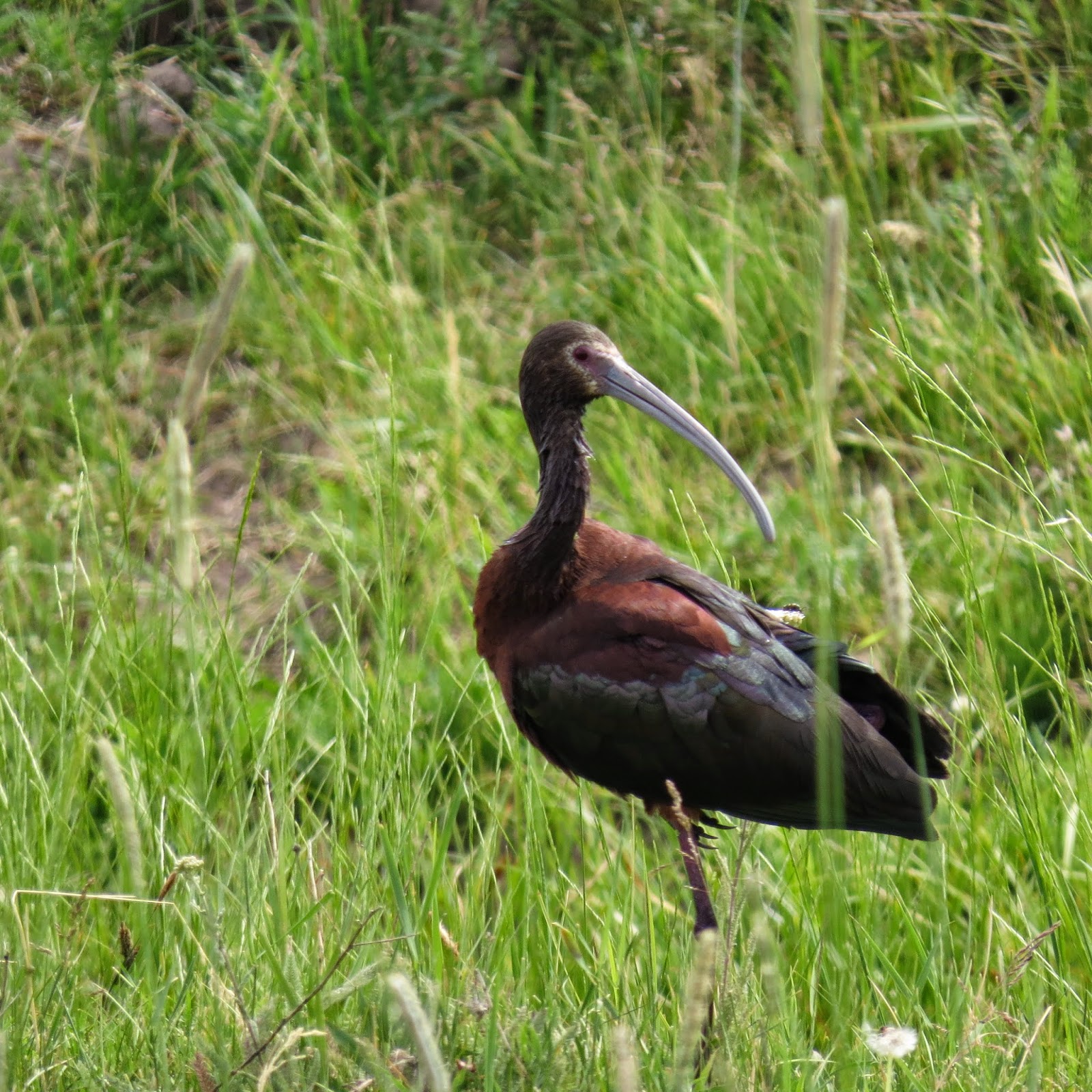
I got to Seney NWR soon after it opened for the day and drove the 7-mile auto route. There are over 75,000 acres of refuge here with a successful Trumpeter Swan re-introduction. I saw several pair including this one with their single surviving cygnet.
Trumpeter Swans in Seney NWr - MI

Part of Seney is also a designated National Wilderness.

EN.WIKIPEDIA.ORG

The National Wilderness Preservation System (NWPS) of the United States protects federallymanaged wilderness areas designated for preservation in their natural condition. Activity on formally designated wilderness areas is coordinated by the National Wilderness Preservation System. Wilderness areas are managed by four federal land management agencies: the National Park Service, the U.S. Forest Service, the U.S. Fish and Wildlife Service, and the Bureau of Land Management. The term wilderness is defined as “an area where the earth and community of life are untrammeled by man, where man himself is a visitor who does not remain" and "an area of undeveloped Federal land retaining its primeval character and influence, without permanent improvements or human habitation, which is protected and managed so as to preserve its natural conditions."[1] There are currently 757 designated wilderness areas, totaling 109,511,966 acres (44,317,920 ha), or about 4.5% of the area of the United States.

So these are refuge systems also, apparently just not "managed" in any significant way and sometimes part of the NWRs.

Seney is one more refuge with lakes and woods and marshes, soothing to the eye, no cottages or billboards or commerce or utility poles. It must be stunning in the fall. There were ponds covered with white waterlilies near the VC where the staff was visiting and getting their respective daily agendas in order. It was beautiful refuge. 

The sky cleared as I approached the Big Mac; there were high wind warnings posted for the bridge but it was already calming by this time. 

On down into the Lower peninsula through woods and fields and across rivers to Big Star Lake and Lake Michigan where I spent the next several days with family.

Blue Goose ~ Day 51

July 21, 2014 ~ Superior, WI to Marquette, MI
I found the Red Mug, a coffee shop slightly below ground level with a bakery upstairs in a solid older building near the downtown. It was already very warm in the bakery but the downstairs was cool and another good local coffee shop with baked goods, sandwiches, soups and salads. Locals almost always occupy one table, discoursing on politics, weather, the markets, the news…Travelers and tourists come for their morning caffeine fix and either stay (like me) woking on a laptop or continue on their journey.

Heading east I made an unplanned decision to tour the Chaquamegon Peninsula and spent most of the day doing exactly that, lingering at The Apostle Islands National Seashore for a couple of hours.
Apostle Islands National Lakeshore - WI
There are 22 islands, and in 1970 all except Madeleine Island were designated a National Seashore. Gaylord Nelson, a former governor and then Senator was instrumental in this grand acquisition. There are still a few in-holdings, which will remain in private hands until the death of the current genration. The land cannot be willed or given away. It becomes federal property, your property and mine, at that time. There are T-shirts stating The Lake is the Boss and it is. Kayaking to the islands is a popular way of getting there, a 2-3 mile trip over open water to the nearest, and everyone is cautioned about the hazards of wind, water and hypothermia. Some of the islands have lighthouses, and in the winter, ice caves form. The peninsula is a broad inelegant jutting of land, which attracted northern Europeans, some of whom tried farming but often turned to fishing instead. There is some logging and now a well-established tourist industry. The town of Bayfield is 
situated on the hills rising from the shores of the Lake and has gorgeous, grand, old homes, the handsome renovated brownstone Apostle Island Visitor Center, a beautiful Carnegie Library and the usual businesses for tourists. I saw a bare-chested Native American with two long black braids, moving slowly down the sidewalk with an ice-cream cone. There is so much more acknowledgment  of the importance and reality of Native Americans nearly everywhere I visit than I remember from previous visits....books, signage, maps, historical markers….

I watched two separate groups of kayakers prepare to make the trip to Sand Island, both with a young male guide. Off they went in their 5- and 6-kayak flotillas. Some do day trips; some stay and camp a night; some paddle to other islands. There were two Coast Guard boats at the dock and NOAA printouts of the weather and wind conditions for the day. There is always history wherever one goes and here also, and I sometimes will buy book about a specific area but here, even the paperbacks were expensive. The one I really wanted was $35; I didn’t buy it and found a couple less expensive books. It was very warm but pleasant enough, making it easy to just hang out, mostly chatting with the volunteers in the VC and then watching the kayakers prepare and set off.  
Kayakers heading to Sand Island - Apostle Islands National Lakeshore - WI

Just west of Ashland, WI, is the Northern Great Lakes Visitor Center situated on property that is contiguous with Whittlesley NWR. It took a while to find out exactly where the boundaries of this little refuge were but eventually, after driving on the roads near the VC, I found the NWR sign, which they all have, at a little road leading to a closed and shuttered Environmental Education Center and a few unfinished trails. It’s a work in progress involving the watersheds of three creeks running into Lake Superior which historically had been dredged and altered. The coaster brook trout, a threatened and endangered species due to habitat degradation (in this case, mostly sedimentation as a result of logging / agriculture) is the “poster species” in these creeks and Whittlesley's mission.

I thought I would sit for an hour here but lasted three minutes and then tried again on a little bridge over one of the creeks but that didn’t work either. Too hot; too many bugs, so I left and continued driving into Michigan’s Upper Peninsula where I stopped in Ironwood and settled in a Walmart parking lot at a slight elevation above US2, where breezes kept things tolerable and where I had cheese and crackers and a glass of wine for dinner. I fully intended to stay there for the night but had been texting Deborah and made the decision to get to her lake cottage the next night. Which was why I drove another two hours, staying in Marquette instead. The sun slowly set off my left shoulder, a bright orange-red, discretely defined, perfect circle moving through a light gray haze. 

I used the bathroom in Walmart and noticed a sore on my foot, in addition to intense itching on my knuckles and ankles from deer fly bites…and then the sore area on my foot seemed to be spreading quickly, and I remembered a recent NPR story on a quad amputee who had had group A strep so typically got a little freaked out. I cleaned it, put some antibiotic ointment on and went to sleep but was awakened by wind at 0415 and my foot was worse and I couldn’t sleep and googled group A strep and freaked out some more and wished for daylight and the van was shaking with the wind and grocery carts were rolling around in the parking lot, and....I finally fell back asleep, waking in daylight. 

Monday, July 21, 2014

Blue Goose ~ Day 50

July 20, 2014 ~ Baxter, MN to Superior, WI

Baxter is in Crow Wing County.

I spent the first hour last night swatting mosquitoes in the van. Finally, I completely closed all the windows, put a Skeeter Beater on one and then opened it part way which seemed to fix the problem. I didn't think there would be many in a Walmart parking lot.

I've been doing some research on Walmart but haven't come to firm conclusions / opinions yet. They do not pay their employees well and there is the issue of medical care which now may be moot, given the Affordable Health Care act. How do they compare to stores like Best Buy, Target, Costco, Starbucks, the big chain grocery stores and restaurants, Staples, Office Max, etc. ?

That small local stores and shops and restaurants offering consumer services have been affected is true but by nearly every type of business, not only Walmart.

While traveling, I buy things I need in Walmart because I feel it is a courtesy to do so after sleeping for free on their premises. I have been surprised both at how inexpensive things are and how often their merchandise is not all that different from a Meijer's in Michigan.

Walmart employs a lot of people, and those with limited means buy necessities or just buy into the American dream of non-discretionary stuff at a Walmart and pay less than at most other stores.

There actually are discussions on the Internet about whether Walmart is "good or bad" for America. I personally usually don't choose to shop at Walmart but is that partly elitist?

OK, so that's one of the things I've been thinking about.

I Urban Spooned "coffee" for Baxter and came up with Caribou Coffee, but when I drove there, I saw a Starbucks. I wondered about this and later figured out Caribou was just down the street, alive and well and not usurped by Starbucks. Caribou, BTW, is based in Minneapolis and is the second largest coffee chain.

Starbucks was busy on this Sunday morning with an ethnic homogeneous clientele, many probably coming or going to church.

Rice Lake NWR is 50 miles east, a wonderful and pristine refuge, beginning at the main offices right off the highway, with a Purple Martin house and small gardens of blooming summer flowers. Being a Sunday, it was closed of course, but there was also a sign on the door apologizing that the offices might be closed at other times due to "staff shortages." I picked up a map and first went to  a fishing access on the Rice River where I saw someone hauling in a large fish. As I drove closer, I saw the someone was a middle-aged woman who said she usually catches Northern pike but this was a bass. I hung around here for awhile as the wind was strong, eliminating the insect factor.  Another middle-aged woman drove in with a camera and wandered around, taking photos; a father with three young boys came and started fishing, and then two more fishermen.

Rice Lake NWR - MN
The garbage can had been removed because of "hungry bears, so please take your garbage with you."

Everything about this refuge was done well with marked routes, interpretative signs and several picnic places. At one of these, which was on the shore between two tiny lakes (Twin Lakes), there was a group of Native Americans, their cars blocking the loop through the picnic area. I suppose they checked me out as I slowly turned around and continued through woods and fields to a point which bordered Rice Lake.

Rice Lake on the Rice Lake NWR - MN
The leaves were making a swishy / shushing sound in the wind. Wildflowers were in bloom, including the striking Michigan Lily.


EN.WIKIPEDIA.ORG

The Refuge's history centers around the 4,500-acre (18 km2) Rice Lake which, for thousands of years, has supplied an abundant wild rice crop. Each fall, the bountiful rice attracts hundreds of thousands of waterfowl, as well as American Indians who harvest it using traditional methods. Rice Lake is known for its tremendous number of ring-necked ducks. Because of the high concentrations of migratory birds, Rice Lake Refuge has been designated as a Globally Important Bird Area by the American Birding Association.
Today, there were few birds, although I flushed a Northern Harrier and would occasionally see smaller birds, but the deer flies and other insects were incredibly abundant. Billions, so no hiking here; instead a pleasant drive through the property, always closing the windows at any stop or even while driving slowly. It must be stunning in the fall and winter. The trails in these northern refuges are 10-12 feet wide mowed paths, easy to follow and almost certainly used for X-C skiing and snowshoeing.

Leaving Rice Lake, I continued east in the late afternoon on a nice road, past lakes, through forests and fields and small towns. I saw three Sandhill Cranes.
Sandhill Cranes - northern MN
The latitude is that of the Upper Peninsula of Michigan, definitely at a remove from busy cities. There is a huge tourist industry based on fishing and North Woods cabins. I entered the "Lake Superior Basin," and in Duluth went over the "Richard I. Bong" bridge which name made me laugh. The temperature dropped here from 83 to 66 in minutes. Such is the effect of the lake.

I stopped for dinner at Grizzly's on the south side of Superior, WI, and had salmon, glazed with a bourbon sauce, and (amazingly) a delicious hash brown / cheesy side dish. And a good salad. Tomorrow I will not eat dinner in a restaurant!


Sunday, July 20, 2014

Blue Goose ~ Day 49

July 19, 2014 ~ St. Cloud, MN to Baxter, MN

After working three hours, I headed east 20 miles to Sherburne NWR, one of the more popular MN refuges as it is large and fairly close to the Twin Cities. There is a Prairie's Edge Wildlife Drive on which I dawdled a couple of hours, all the while being followed by a car with four birders moving at the same pace. Sherburne is in the transition zone between coniferous forests and prairie which is reflected on this refuge. A kiosk at the beginning of the route had current bird and blooming flower information (as of yesterday; often, the posted sightings are several weeks old). I saw Lark and Vesper Sparrows, a pair of Baltimore Orioles, Cedar Waxwings, several Bald Eagles, Trumpeter Swans, Wood Ducks, Black Terns, a Brown Thrasher, American Robins, Green Herons, Barn Swallows, a Pileated Woodpecker, Red-winged Blackbirds and heard Common Yellowthroats and Marsh Wrens. The sky over the marshes was overcast but it was warm.

Before I drove, I had walked 2-1/2 miles on the Blue Hill Trail and nearly got driven insane by flying things. It was horrible! Since the wind was blowing and it wasn't sunny nor too warm, I thought I'd be fine, but I soon began using my hands as wipers moving back and forth in front of my face, always hitting away bugs.
Butterfly Weed on Blue Hill Trail in Sherburne NWR - MN

Saving graces were few mosquitoes and that my new walking shoes were comfortable. Also, I was wearing a hooded sweatshirt which was too warm but protected my head and neck. Needless to say, the birds I did see merited fewer than 10-second glimpses before the flies gathered on my outstretched hands and bare ankles. Part of the trail went past Buck Lake. Lakes up here, I am learning, are often watery places filled with reeds this time of year. On the auto route, the open water areas were called "pools" as in "Stickney Pool" or "Little Bluestem Pool."

I somehow lost my trail guide along the way but was 95% sure of the route and did find the trailhead without difficulty. Jeez louise.... I would not have done this had I known but didn't regret the much needed exercise, and I am not sure what an effective deterrent would have been. At least I wasn't bit or stung much. I sat in my car drinking water and eating an apple while the sweat dried.

But this is the North Woods in the summer, which is why all the refuge pamphlets hereabouts advise "insect repellant is advised" if visiting this time of year.

Sherburne is a wonderful place with obvious efforts made to attract you and me to visit and explore. It's our property after all.
Sherburne NWR - MN

So, the late afternoon question? Where to sleep?

How about Father Hennepin State Park on the huge Mille Lacs Lake? Unfortunately, it was full. The young guy in office told me it would have cost $27 to $30 if I had been able to stay since I would have had to buy a Minnesota State Forest Annual Pass.

I was hungry so stopped at Muggs in Wahkon, and had a $9 cheeseburger with fries, eating outside and reading Bird Sense which helped. I need to prepare better for inevitable hunger pangs. It's not rocket science that I'll get hungry.

The smallest NWR is Mille Lacs NWR and consists of two tiny islands in Mille Lacs, Hennepin, which is one-third of a football field in size and Spirit, one-quarter of a football field. These are rocky, gravelly islands, protected for nesting Common Terns, a threatened species in Minnesota. I drove into several fishing ramp areas and finally saw Spirit Island.
Mille Lacs NWR - MN (Spirit Island) 

Sleep?

First I pulled into the Mille Lacs Casino and drove around the parking lots for 10 minutes. OK, I could do this, but the longer I sat there with little sign of any humans, even though surrounded by hundreds of vehicles, including many trucks with fishing boats on trailers, the more I felt I didn't want to stay next to this huge casino where people were inside throwing away money in buildings where the sun doesn't shine. Of course I speculated on the emotions attendant to such activity. Like, who knows what craziness could occur for a big loser late at night. There were security vehicles and signs of "24-hour surveillance" but it was too quiet and cheerless. Does it say something when I compare a casino parking lot to a Walmart lot?

I ended up 20 miles west in Baxter, MN, again at an almost park-like Walmart with trees and landscaping, on the southern edge of the city. Well, not exactly park-like, but still pleasant enough.

I need to keep current with this. I spent too long this morning trying to remember where I was just three days ago...what city? what state?


Blue Goose ~ Day 48

July 18, 2014 ~ Brookings, SD to St. Cloud, MN

Woke up at 0830! A huge RV from New Hampshire was next to me. The owners were towing a small car. I got a glimpse of them and was surprised by what they looked like which I will leave to your imagination.

The McCrory Gardens: I had to check this out as a gentleman told me all about them at Perkins the night before, saying they were in the "top ten" of gardens (I think he said world wide, but maybe just the US). They were impressive, if one likes such venues, with no obvious insects and very few birds but thousands of flower beds and trees, all nicely labelled. I so quickly get fatigued in these places. Perhaps one needs to live nearby and visit in small time increments to really appreciate what they offer. I kept thinking the gardens must be heavily sprayed to keep the bugs away which is impressive manipulation when considering flora. Still, the public wouldn't come if they had to contend with constant bugs, but also the birds don't come. The park in Flandreau along the river was also free of insects. It's a dilemma....

I drove an hour to Big Stone NWR just across the border into MN.

"Big Stone County received its name from Big Stone Lake. The name was a translation of a Sioux name for the outcrops of granite and gneiss found in the Minnesota Valley not far away."

The auto route wound through a variety of habitat. The massive rocks seemed like a tiny bit of the Colorado Rockies popped up here and there.
Big Stone NWR - MN
Once more, while there were occasional birds, the middle of July in the middle of a day is perhaps the least opportune time to see much. A brilliant yellow American Goldfinch perched briefly on a roadside branch next to my car as did an Eastern Wood-Pewee. Cormorants sunned themselves; a few gulls flew about. Big Stone has a recently renovated headquarters and gets first prize for bathrooms, rivaling the one at Necedah NWR, all bright blue and white tiles. The woman behind the desk was friendly and helpful, and there was lovely little diorama showing 8-10 fauna of the area. Some of these refuges have an understated appeal that increases as one checks it out, and this was one of those.

Stopped for munchies and coffee to keep me awake, including a big piece of "Chewy Praline" fudge. Working on it...working on it...not giving in to immediate gratification.

I checked into a downtown hotel in St. Cloud, MN, with a room overlooking the Mississippi River and worked a few hours, taking a break to eat downstairs, where I had an overpriced pasta dish but a good salad. People were extending Happy Hour, TGIFing, eating outside on a terrace and relaxing well into this warm summer evening.

I tried to read an Amy Tan book but left it in the room. I usually like her writing but couldn't get into this one which was The Hundred Secret Senses. I skimmed it though so got the general story line.
Prairie at Big Stone NWR


Blue Goose ~ Day 47

July 17, 2014 ~ Mitchell, SD to Brookings, SD

I have been driving too long, too far each day and need to slow down, although getting to Michigan for a family beach vacation is part of the reason. Also, distances between points west of the Mississippi are often 100s of miles.

Anyway....I decided today would be easy. The first thing I did was spend three hours in a downtown coffee shop, which was adequate and midwestern - coffee OK and an small omelet with predictable with tiny ham junks, a few barely discernible veggies and cheese but satisfied my morning protein fix.

A guy was sitting at the table next to me, typing away. When he got up to use the restroom, he asked if I would "please, could you like stab someone, or scream or something if they ..." and he gestured toward his stuff. We talked a bit later. He lives in California but came back to Indiana to buy a new Prius, and we talked about what kind of mileage he gets (not as good in the city because of the electrical system kicking in or something...I know I don't have this quite right, but he gets close to 45 mpg on the open road.) He is a photographer and was stopping by the major magazine markets (New York, Chicago, Portland, Seattle) with his portfolio.

(Re gas mileage, if anyone is interested, I am consistently getting 28+ while driving steadily at 70 mph; I am pleased as the specs say 23 in town and 25 on the highway.)

A chatty group of local women came, ate and left, at which time I knew I had stayed long enough.

Next task was to get the oil changed, which I did at LubeRangers for $50.

Then I went to Cabela's and bought a pair of walking shoes. My old Keens were duct-taped and one had a sharp little projection that had given me a blister on my heel last time I wore them, so it was time. I had forgotten that Cabela's is a mostly a hunting and fishing store. Half the clothing items were camouflage patterns. I also bought a freeze-dried camping breakfast and another can of fuel as I intend to stop spending too much money on gas station food or dinners.

There were no NWRs on my agenda today, so I did something on impulse and went to Flandreau, SD. There had been an Indian boarding school there (I never did check this out but have always been interested in this subject. There is, of course, all kinds of information on the web. This site is worth reading: jaie.asu.edu/v35/V35S3run.htm)

Flandreau also has a city park that was on a SD Birding Trail brochure. So I headed there through corn field and hay bales and the neatest cleanest landscape I've ever seen.
Near Flandreau, SD
The large farm houses had great expanses of mowed grass lawns and every single item was perfectly placed and squared with each other.

Flandreau City Park was on the Big Sioux River, and I felt like I was in Zeeland 50 years ago. A baseball game was in progress: teenagers from Madison vs. Flandreau with parents and grandparents in lawn chairs cheering, clean little blond kids running about, a covered picnic pavilion, hot dogs for sale at a concession stand, an announcer, bleachers, uniforms, a perfect bug-less summer evening, ...about as quintessentially 1950s Midwest America as I've seen in a long time. No ambivalent or outright ethnic variety evident; few tattoos; no pink hair; no dirty clothes; no boobs falling out of T-shirts....no evidence of any Native American blood except one teenager.

But there was a tightly shuttered large "Japanese Gardens" building.

And a memorial marker for a Mrs. Joseph Thatcher who died in the aftermath of the Spirit Lake Massacre (in Iowa) while trying to swim across the river just "300 yards east" of this point.

WWW.PANORAMIO. COM

Memorial for Mrs. Joseph Thatcher - One of four settler women taken captive in the Spirit Lake Massacre in March of 1857 by by a Wahpetuke band of Santee Sioux led by Inkpaduta. The uprising was the result of many failures of promised supplies from the government and subsequent treatment of the indians when they went begging for relief in the harsh winter. The marker says she drowned while crossing the Big Sioux River about 300 yards east of the marker. Some accounts say she suffered phlebitis during her captivity and became lame, and although recovering, while crossing the river was pushed into the icy water by braves, clubbed when she tried to climb out, and then shot and left to drown.

And a developing wetlands project with paths and informative trail signs.

And a tiny RV park.

And some homes / cottages along the river. Several of them looked generically cottagey but two or three were obviously very old though perfectly cared for.  One had three light lavender clematis vines on one side, growing high on trellises, partially covering windows, but all flower beds were trimmed and weeded. For some reason, I thought of DHC while looking at them and how she would appreciate this scene. Again, I had a profound sense of remembering some of my childhood places and times.

I walked around the park and by the river for 30 minutes and then decided to sit on a picnic table and watch the game for an hour. I made it through 30 minutes, thinking half the time of brother Bill and the thousands of sports events he watched.

I stayed in Brookings right across the street from South Dakota State University and the 40-acre McCrory Gardens, next to a little pond under trees in a Walmart parking lot which often is more pleasant than not. Surprisingly....

I ate at a Perkins...and won't again, but it was an easy walk


Thursday, July 17, 2014

Blue Goose ~ Day 46


July 16, 2104 ~ Valentine, NE to Mitchell, SD

I had intended to check out Valentine NWR yesterday but it was getting late, and this is a large (over 70,000 acre) refuge, so I had to drive back south 16 miles and then west 13 miles to get to the headquarters. Which were depressing. No one was visible (and this is fine as I don't expect someone to be alert to the very occasional visitor on these remote refuges), but the general impression around the buildings and grounds was slightly derelict and tired, unusual in my experience thus far for a refuge. I read later that much of the work here had been done by the CCC (Civilian Conservation Corps), which is also true for many places out west, and it seemed not much had been done since for upkeep. But Valentine is a huge refuge with major projects, and esthetics for the occasional interested traveler obviously isn't a priority. Like I read that Hackberry Lake, one of the larger lakes, had been mostly pumped dry in 2004 to eradicate invasive carp. The little bit of water that remained was "treated" and the carp killed with a successful outcome as ducks and geese retuned in numbers. But what a prodigious project, pumping a whole lake dry! No question that there is a lot of manipulation / management of refuges. Nearly every one so far has mentioned the practices and rationale for "prescribed burning" and grazing, the problems of controlling invasive flora and the major ways water is managed.
Ranches near Valentine NWR - NE

Before I even got to the headquarters, I sat an hour by Watts Lake and watched things. Surprisingly, I kept seeing Orchard Orioles in White Cedars with juniper berries (birds generally love these), and Lark Sparrows, the ubiquitous Yellow Warbler, Eastern and Western Kingbirds and swallows. The air was fragrant and several species of wildflowers were blooming. One truck drove by in the hour.

The 9.6-mile auto route was pleasant as it wound around the lakes through the sand hills, but for me, there was such a lonely feel out here. I wasn't uncomfortable but am realizing I would never choose to live so far from human contact, no matter how compelling the natural setting. To see these lakes with no habitation, while certainly great refuges for fauna, was just unexpectedly unsettling, realizing all the while that this was my unique perspective and totally a failing on my part to embrace it without carrying on the inner dialogue. Does this make any sense to anyone? I wondered about the families who accompany the refuge managers and who live on them....or the ranching families who live 50 miles from the nearest, even small, town.

But, I did come upon Upland Sandpipers who are always reluctant to fly away but seem to think they can outrun my car, like Killdeer. They are graceful, thin-necked, long-legged birds with a bicolored bill. One encounter was a family with half-grown birds who awkwardly moved about as the parents tried to get them off the road. And then I saw what I hoped was a Greater Prairie Chicken but which finally showed itself enough to be a Sharp-tailed Grouse. We watched each other for 15 minutes. It would stare at me and then finally cross the road in front of the van, peck away at the weeds and then watch me again and cross back over the road to the other side to peck at those weeds. The Prairie Chicken would have been a life bird for me and their range is less more restricted the the ST grouse. But, still, it was fun to have a tete-a-tete with the grouse which I seldom see.
Sharp-tailed Grouse on Valentine NWR - NE

As I pulled out on the main highway, a State Policeman was sitting there but who immediately did a U-turn and took off after a speeder going the other way. I have been driving well within the speed limits and only freaked out once when I was talking on the cell and passed a policeman. Some states have hands-free laws and I am never quite certain.

Back through Valentine to Fort Niobrara NWR where the big deal is habitat for buffalo and elk. I was getting tired of gravel roads, and buffalo are no big deal to me. Well, there actually are, but I used to see them within a mile of my house in Montana all the time so wasn't invested in seeing them as most Niobrara visitors are. I bought a couple of delightful kids' books about wetlands and buffalo as the headquarters actually was open and had a gift store. And then I walked to see a waterfall, one more incongruity in Nebraska, as I felt I was in the Upper Peninsula.

And I did see 20 buffalo and prairie dogs but wanted to get out of Nebraska for some unclear reason, so I drove another long time east and north to South Dakota after making sure I could get across the Missouri River since there aren't just bridges everywhere. Again, this was a road with almost no traffic with the sense of how immense the prairies are. I immediately felt better once in SD; I know, it's weird and inexplicable but that's how it was. I figured I could get to Mitchell, SD, by sunset and still have time to go to Lake Andes NWR, which I did.

What a lovely place! The unexpected gorgeous places I find at the end of gravel roads are one of the pleasures of this trip. I hadn't intended to do much more than drive through, but trails beckoned and I walked a mile, through grasses and flowers with dozens of birds perching on the grasses and flowers. Perhaps it was the time of day. All the refuge literature always say to visit early mornings or late afternoons and I happen to do so. Even on the way to Lake Andes, I spotted a grouse / prairie chicken by the roadside and turned around only to discover half a dozen clumsy, tiny grouselets or chicklets scrambling to get into the weeds and out of site. Of the parent, no sign but a lot of clucking, so I don't know whether it was a G or a C.

In the fields just off the trail in the late afternoon sunlight were many Dicsissels and Lark Buntings but also sparrows and phoebes and kingbirds and a White-tailed deer who didn't realize I was on the trail until we were very close when it bounded away.

The trails were either gravel or widely mowed and wheelchair accessible with marsh overlooks. I saw a Common Yellowthroat which I had heard all through Valentine but never saw. It was very soothing and a nice ending to a long and dusty day.
Lake Andes NWR - SD
The trail area was between Lake Andes and prairie / fields so the habitat is varied. I had Birkies on and later I realized I had picked up dozens of very sharp pointed burs which stuck to the bottoms and which clicked on the floor of the Walmart. So I spent 15 minutes pulling them out. And checked for ticks but still woke up in the night with something crawling on my shoulder.

My googling mentioned that the Cabelas down the street from Walmart was also a good place for parking overnight. I checked it out, but the store itself closed at 9 pm, and I had no bathroom options. Which is why some people pay $50 to $500K for an RV.

The day was another nutrition failure (Rice Krispy cookie, half a lemon bar, McDonald's breakfast burrito, cold leftover Chinese, chocolate pomegranate candy and a too sweet coffee drink from a gas station) and I wasn't hungry so had cheese and rice crackers and read a free liberal newspaper I picked up - Prairie Fire - about tracking, tar sands, conscientious land-steward farming, etc.


Blue Goose ~ Day 45


July 15, 2014 ~ Scottsbluff, NE to Valentine, NE

Upon awakening, I googled coffee shops and found one downtown, which I realize is where many small non-Starbuck-towns have successful coffee businesses. (I guess this is most likely true also for town with Starbucks like Holland, MI.) I found my way to Cappucino and Co. which had very good munchies and meals. I talked briefly with a fellow traveler who also "road-tripping" and was also getting his devices charged. I overhead the waitress / owner ask if she could charge her iPhone using his cable, and that conversation precipitated his story. He had body piercings and sandals, was middle-aged and also worked on a laptop for a couple of hours.

The reason I was in Scottsbluff was to visit the North Platte NWR, which is actually four separate units. One is an island in the Platte River (which was several miles west) and the other three are lakes north and east of town.
North of Scottsbluff, NE
I started north and, while I wasn't lost, seemed to just be wandering on poor gravel roads with a hidden Lake Alice near but not visible, Lake Alice being one of the lakes. So I got a bit crabby and headed for the area of the other two lakes and then happened on definitive NWR signs. I drove around for an hour and had the thought how odd it was to have a lake on the prairie and have no dwellings and no waterfowl either, it being mid summer and all; at least this was true for Lake Alice #1. There was also a Lake Alice #2. The other two lakes did have some cottages on the parts that weren't on the refuge. It is hard to figure sometimes what is refuge and what is state park or private. One of the lakes had a lighthouse, an incongruous site in Nebraska. There was the irrigation thing going on here also with canal and ditches and gates and obvious manipulation of water for farming, and I was not moved to linger even though there were grassland birds all over, including many Lark Buntings. But if my windows were open, the insects were ready....huge flies, small flies, bees, mosquitoes and other unidentified winged things. It gets old soon.....wuss that I am. 

Leaving Scottsbluff, I drove a long, long time due east on a road with very little traffic, stopping once or twice for hawks on poles which were always Red-tailed or Swainson's, or for old buildings.
East of Scottsbluff, NE
Just east of Alliance, NE, I started seeing non-river water in the form of small pothole ponds and wetlands, and the land began changing from browns and tans and reds to greens. This part of Nebraska is the Sand Hill country, a rumpled landscape looking like an gigantic unmade bed, with a million small hillocks overlaid on longer shallower land swells. It is ranching country. There were only occasional trees or small groves and a few creeks, but as I got nearer to Valentine, I began to see small lakes. 

Valentine is near the Niobrara (Nigh-o-brare-ah) River where Fort Niobrara was situated to help "manage" Indian / white behaviors. This town with a pretty name wasn't especially attractive. I did have a delicious meal though in a truck stop restaurant...hamburger steak and good mashed potatoes. The meat was lean and tasty, with a rich brown gravy and lightly fried onions and mushrooms. And a good comfort-food chicken noodle soup. And pies in a case next to me which I did resist as I had a lemon bar in the cooler. I guess veggies and salads do not have a high priority with the customers. Better none than some awful salad and overlooked vegetable. 

It was one of those times when I drove around town looking for somewhere to sleep and ended up right next to the restaurant as the parking lot was gigantic. As usual, it was fine, although my vehicle is in need of a shake-down cleaning soon. And the issue of personal cleaning up continues....as I refuse to do anything in a shared public restroom or if the restroom is at all marginal. 

Blue Goose ~ Day 44

July 14, 2014 ~ Big Bend Campground, CO to Scottsbluff, NE

The campground was serene and warmed up once the sun got over the mountains. I walked by the meadow, listening to buzzing hummingbirds and Chipping Sparrows and watching Yellow-rumped Warblers before leaving in search of coffee, which found that 20 miles down the road but immediately got distracted by the six hummingbird feeders around the store. There were dozens, if not hundreds, of hummers constantly visiting the feeders. I took at least 200 photos and even after discarding, I still have 45 of them (most of which will eventually be deselected).
Female Broad-tailed Hummingbirds - along US 14 - CO

Male Broad-tailed Hummingbird - along US 14 - CO
Getting neighborly with Broad-tailed Hummingbirds for an hour in the morning sunshine in the Rockies is a perfect way to start a day. The woman in the store said they get two species...one was the Rufous which just starting coming and were often "nasty little birds" and another species she had trouble remembering but knew it had a red throat. As far as I could tell, these were all Broad-tailed. This was such an unexpected pleasure...more than compensating for the marginal coffee.

I wasn't quite sure I was through the mountains until I popped out suddenly where I turned north into Wyoming again. But before that,  I drove in the Cache la Poudre River canyon past more lovely campgrounds, including one named Dutch George, occasionally watching whitewater rafters, on a winding, winding road which meant moving slowly, and once waiting for work crews working on a slump repair which means the road basically slumps into the river or down a mountainside. Of course there were many warnings about "Rocks" which I guess means they could be in the road or come down on one's vehicle. There were also areas of a previous burn with warnings of possible landslides and flash flooding, and that one should "Climb to Safety." Handsome Black-billed Magpies flew about and it was comfortably warm but not hot. One-third of the land in the US is federal land (our land) and there were several National Forests along here, interspersed with modest private cabins and home. There were also signs indicating "No Snowplowing betweeen 7 pm and 5 am. "

The road north from Colorado into Wyoming went through wide open land, the transition zone from prairie to mountains, with beautiful blush-rosy-brown (lipstick colors) rock formations. The sky was soft blue; the grasses a delicate green; dark mountains to my left, some with snow on the top.

Not far from Laramie is Hutton Lake NWR. I had to drive 10 miles on a wide gravel road toward distant mountains to get there, and the road was better than the refuge which had a few drying lakes and bugs. Not that all refuges have to be perfectly suited for human visitation....I am continually grateful for whatever powers and people create and implement these sanctuaries.

WWW.FWS.GOV
Several roads traversing the Refuge provide access to all five lakes. Spring waterfowl flights can be spectacular with large concentrations of migrating waterfowl, especially redhead and canvasback ducks. Shorebirds and raptors also frequent the Refuge. Several prairie dog towns along the roads offer a close-up view of white-tailed prairie dogs.

The White-tailed Prairie Dogs seemed incredibly dimwitted as they burrow in the middle of the road and would stand tall by their burrows waiting for cars to drive over them. Several times I worried that I smashed one, but perhaps they dive down at the last minute as I never felt bumps or heard death squeals. The scenery was just awesome, and I parked along the road for an hour watching birds on fences, most notably a McCown's Longspur which would fly up and lark about with translucent white tail spread wide and then return again and again to a fence line. The field guides and Pete Dunne don't give this bird enough beauty credit. Its shoulders are chestnut; it has a rounded black bib, a black band on the tip of its tail and white and black facial markings and the delightful way the sun shines through the tail as it flutters about in the sky. I got a few photos after fussing and experimenting with my camera most of the hour and was about to leave when a local sheriff's deputy pulled in behind me to check things out. I assured her I was fine and showed her the picture of the longspur in one of my field guides. She just wanted to make sure I didn't have car trouble and was OK.

On impulse, I got my hair cut in Laramie and poked around a Murdoch's (western chain out west) for T-shirts or other gift possibilities but found nothing...A few cute and very expensive T-shirts but in larger sizes. The jewelry was locked up so not in my price range. I guess this is where the rodeo people shop, and the ranchers and farmers.

I continued on I84 through Cheyenne, and at Kimball, NE, turned north to Scottsbluff where I spent the night and had decent food at The Wonderful House, a popular Chinese restaurant. I had a beef and broccoli dish because I am learning to order food appropriate to the location.


Tuesday, July 15, 2014

Blue Goose ~ Day 43

July 13, 2014 ~ Rock Springs, WY to Big Bend Campground in the Rockies in Colorado

I lingered awhile in Rock Springs, half wanting to go to at least one rodeo performance but couldn't find ticket information online, and it would mean hanging around until evening....

Back on I80 which is efficient, its only redeeming factor. The road ran fast and straight through more sage and sun until I turned south early afternoon into Colorado and immediately the scenery changed. As I got closer to the Rockies, there were prosperous ranches and green fields and far-off snowy peaks.


I crossed the Platte River three times, stopping occasionally to read the historic markers, most of which describe various pioneer trails.

After getting gas in Walden, a small nondescript town but busy with travelers, I drove another eight miles south to the heart-stoppingly gorgeous Arapaho NWR.
Arapaho NWR - CO


Swainson's Hawk - Arapaho NWR - CO
I picked up information and refuge maps, drove an auto route and sat by a pond for an hour where I mostly watched parent and baby coots, but also a Black-crowned Night-Heron which flew over, and a gull which made several dive-bombing runs toward the baby coots, very concerning for the parents who flapped and fluttered about. The babies all dove out of sight, and the gull left after half a dozen futile attempt at a baby coot dinner.

I had found a spot where oddly (because it was on the edge of a wetlands) there were no flies or mosquitoes. Otherwise, I wouldn't have lingered. I drove up on Owl Ridge and saw a Swainson's Hawk sitting on a post and looked down on the narrow winding Illinois River hoping to see a moose. I didn't but reveled in the overall beauty of this refuge.

Late afternoon, I headed east on US14 which goes into and over the Rockies. I started in sunshine but then went through 15 minutes of rain while driving over a 10,000 foot pass stopping constantly to take photographs in between rain drops. I know from previous experiences these pictures NEVER even begin to capture the wild whitewater rivers and immense rocks and boulders and millions of evergreens and the wildflowers and even in July, the patches of snow at higher elevations. There are always places to pull over so the temptation is constantly to do exactly that.

I kept driving by National Forest campgrounds and decided - why not? so turned around and went into the Big Bend campground. There were only eight to ten spots, three of which were for "walk-in tents" only, but there were at least four empty other places, each with a picnic table and fire pit. The deal is that one picks out a spot, enters some information (car license, zip code, etc.), puts money in an envelope and into a small receptacle with a narrow slot on top. I paid $7.50 which was half price because I have the Golden Age Passport which can be used for one night. (Richard - do you have that?) I discovered that these campgrounds are run by a private entity called American Lands and Leisure under contract with the Forest Service. Each has campground hosts who live in RVs with plants, cute signs, outdoor furniture and a definite air of being settled in for the summer. The bathroom was a pit toilet and spotless.

The amazing thing here and which I noticed almost immediately were hummingbirds buzzing as they flew rapidly all around. They seemed to inspect me and my van and several times were hovering two inches from the closed windows or buzzing very close to me. One came flying right at me with its bright red throat clearly visible. I mixed up some sugar water but only had a small plastic bowl to put it in. If I had had a hummingbird feeder, I would have been able to attract them within five minutes, As it was, I had cleaning solution in a red plastic bottle and put that on the picnic table next to the sugar water, and off and on they inspected that but never found the water. I checked my bird guides; this was a life bird for me: Broad-tailed Hummingbirds which were the only possibility with habitat and tail and red throat and geographic location. I was alongside a river, a meadow in front and huge cliffs behind me. It was definitely several steps up from a parking lot or crummy motel.

I hadn't planned this so only had Chobani yogurt and cheese and crackers for dinner which were easily sufficient. I only regretted not having coffee cream for the next morning. It got in the 40s as I woke up chilly, but then I had a Skeeter Beater on one window all night instead of rolling it up.

One more van came in at dusk and I could see its inside light in the dark. Andree gave me an LED head lamp which works perfectly and much better than my other three clip-on reading lights. So, I was a happy camper.
Coots on Arapaho NWR - CO

Arapaho NWR - CO

US 14 - CO

Blue Goose ~ Day 42


July 12, 2014 ~ Kingston, WY to Rock Springs, WY
I worked until noon, washed my clothes, got gas and two large slices of Everything Pizza at the gas station (one slice for $3.59; two for $5, so of course I bought two). No ice needed as it was still rattling around in the new cooler. The motel guy eventually showed up at the desk as another gentleman and I waited, ringing the bell numerous times. He was still in stocking feet and wearing the same grey T-shirt and jeans as last night. He had to rummage somewhere underneath the counter for quarters so I could use the washer and dryer...but he had a lazy nice smile. 

Back on I80, I drove east, feeling sleepy for some reason, up and down long grades with sagebrush high desert on either side of the road and very little else. After 100+ miles, I headed north to Seedskadee NWR. The name of this refuge is from the Shoshone "sisk-a-dee-agie"meaning "river of the prairie hen" and I expected trees and water - cool pine forests, based only this lovely name. Not exactly...
Seedskadee NWR - WY

It was 28 miles north of the interstate and the web site said it could be "bitter cold" as it was over 6000 feet. However, most of the state of Wyoming is over 6000 feet. In fact, the average mean elevation is 6700 feet, second highest in the nation. (Colorado is highest with mean of 6800 feet.) Not bitter cold; utterly silent; sunshine; sage; flies and mosquitoes; blue blue skies and the Green River. This refuge is another "mitigation" refuge, mitigating the habitat damage of the Fontanelle and Flaming Gorge dams. Seedskadee protects 36 miles of the Green.

Since it was Saturday, I didn't expect anyone but it is unusual to be where one can see forever and hear nothing. There were a few birds but the huge flies and other unidentified flying insects, plus the mosquitoes plus the heat plus rattlesnake possibilities plus failing walking shoes precluded even a short ramble out of the car, so I drove on refuge roads near the river where I saw a gentleman and his two dogs fishing from a drift boat. I love these western rivers.

The headwaters of the Snake are in the mountains of northwestern Wyoming. It runs south and then west through all of southern Idaho. Near the border with Oregon, it turns north, flowing through Hell's Canyon and empties into the Columbia in eastern Washington. It has 16 dams! References describe these river as being "used for" irrigation and hydropower.

The Green also begins in western Wyoming mountains and generally runs south to Utah where is joins the Colorado. It has two major dams as mentioned above: Fontanelle and the huge Flaming Gorge.
Green River on the Seedskadee NWR - WY

EN.WIKIPEDIA.ORG

The Flaming Gorge Dam in Utah is a significant regional source of water for irrigation and mining, as well as for hydroelectric power. Begun in the 1950s and finished in 1963, it was highly controversial and opposed by conservationists. Originally, a dam was to be built in Whirlpool Canyon, but the conservationist movement traded the Flaming Gorge dam for halting that proposal. Apocryphally, the Sierra Club, a not-for-profit environmental organization, lost its tax-exempt status for political action in opposing the proposed dam.

I spent a couple of hours in a Starbucks in Rock Springs and then discovered it was adjacent to a Walmart with many other obvious overnighters so I joined the crowd. Impressively, everything always quiets down by 11 or even earlier. There were a few simple conversations at the open doors of RVs but none of the RV park hoopla.

It was windy and the western sky had a mess of complicated clouds with the sun moving through them. I learned the next morning that the National High School Rodeo Finals were to begin in Rock Springs that day. I watched kids and their families bustle about, all with well worn cowboy boots, including one girl with long Goldilocks curls, wearing a red jacket denoting her a "2014 Contestant." She had that "whateVer" expression on her face. There was also a trio that interested me: a nicely dressed middle-aged couple and a young Chinese girl, and judging from their conversation, they were just getting acquainted. She was explaining how iPhones have an abbreviated language for use with Chinese; no way would all the Chinese characters be used.

One other time, years ago, I had travelled through Rock Springs and remembered it as a windy gritty town out in the sagebrush just off the interstate. It apparently has made itself into a viable regional center for commerce and culture in western Wyoming but definitely predominately a ranching cowboy culture.

Sunday, July 13, 2014

Blue Goose ~ Day 41


July 11, 2014 ~ McCammon, ID to Kingston, WY

Everyone was up early at the Flying J, bustling about, getting ready for the day. I got coffee (surprisingly good) and a slice of a Western Omelet pizza (surprisingly good) along with a dozen or so burly guys also getting coffee and food (and a few women). I drove east to Soda Springs (passing near the town of Grace and thought of Dave and Ellen) where I stopped at a supermarket to buy dental floss and came out with the very same model of cooler that Steve wanted to buy for me in Florence but which I declined knowing, if I waited, I could pay $10 more for it in Soda Springs, ID…just kidding. Sorry, Steve…I should have accepted, and it fit perfectly (as Steve said it would). Since I have been buying ice at $1-2 a bag nearly every day, it will soon pay for itself. 

The road to Grays Lake NWR is the same road that goes to Jackson, WY, which, Joanie, is as close as I will get to Drew and his hot plate. It was a lovely scenic road, curvy, but easy to drive. There are many big RVs everywhere out here, and I was behind four of them most of the way, which was fine. Zen Driving is the thing with me lately. We carefully edged past bicyclists and watched for open range cattle. I wanted to coninue over the big mountains into Jackson just for the ride as the road was good, the sun was out; it was summertime….

Grays Lake is a shallow depression with marshy areas and pioneer / mining history. The refuge was open although I didn’t see or talk with anyone. The route around Grays Lake is about 25 miles and easy driving on gravel.
White-faced Ibis at Grays Lake NWR - ID
I saw perhaps three or four cars even though there are scattered ranches around the "lake." The map showed a boundary called Lake Meander which I gather was the historic lake bed or even its furthest reach in the spring after snow melt. Lake Meander…whimsical. 

I soon saw a White-faced Ibis and a cooperative Swainson’s Hawk, not at all spooked by my presence. A coyote ran in the distance. I passed a sign advertising bird houses for sale and immediately thereafter was half a mile of bird houses on fence posts, inhabited by Mountain Buebirds and Tree Swallows.

Mountain Bluebird at Grays Lake NWR - ID
So essentially, this was a large open flat place with mountains all around.  At the south end were aspens and Douglas firs.

I retraced my route to Soda Springs and went south to Bear Lake NWR which was another serene and bountiful marsh, with canals to help manage things. It is called Dingle Marsh by the locals. Here, as at Malheur, invasive carp are a huge problem. They are bottom feeders, uprooting vegetation and muddying the waters, effectively messing up habitat for the water birds.  (The water on this refuge is part of the contiguous huge Bear Lake.) So this is a management issue...trying to eradicate carp or reduce their invasion through dikes.

It was late afternoon, and as usual no one was out here. It was a Marsh Wren mecca. I saw several nests, up to four at once, and often the tiny birds would fly in hanging on the reeds, singing (chattering) constantly. My tires got loaded with Canada goose poop. The goslings look nearly full grown and could fly out of the way as I approached. 

I made a Priceline reservation in Kingston, WY, and on the way almost drove past Cokeville Meadows NWR, which is only accessible from the road, although there was a very short loop trail, an information kiosk and a viewing bench overlooking open wetlands.
Cokeville Meadows NWR - WA
A woman and teenage boy were also looking things over, binoculars at hand. Her husband stayed in their RV. She knew of Crystal Lake and Frankfort where her family had had a cottage "for many generations...and ya know...people say you can't go back again, but you can here...I did and nothing has changed." She now lives in Washington state and they were returning home. Again, in retrospect I wish I had asked the kid if he was also interested in birding. He was taking photos of the cliff swallow nests in the kiosk. I love to see the kid-bird connections. 

The brilliant late afternoon sun, the blue skies and distant grey mountains were a quintessentially western scene as drove into Wyoming. 

The motel...jeez louise. It was listed as three stars and a "smart deal" but it was at most half a star. The guy at the desk eventually showed up in stocking feet, almost certainly under some drug influence. He was nice enough and intelligent and not grubby but had that way slowed-down manner, and he rambled on and on about Priceline and "entities...bookings...front desk/front deck...scams" most of which I stopped trying to follow after two minutes. He had a bit of trouble getting my room key which seemed to be in a box on the floor. And then had to "check the room a minute" before I went in. It was relatively clean, although the bottom sheet didn't fit well and looked as though it had been washed 200 times. Luckily the Internet connection was fine, so I worked several hours after getting Tex-Mex food down the street. Wherever there is intensive farm labor to be done by hand (picking, weeding, hoeing, shoveling, moving water pipes) there are Mexicans in jeans and hats, and they obviously have settled in many towns and communities all over the west. 


Blue Goose ~ Day 40

July 10, 2014 ~ Nampa, ID to McCammon, ID

Yes! There was a Starbucks in Nampa just down from the Walmart and after that stop I got on I84 and drove 75 mph for a long time, passing semis generally moving at 65-70 mph. Weirdly, the temperature, though it varied from 85 to 95 degrees, was not unpleasant even though the sun was out again after a few days of clouds. The van continued to get between 27 and 28 mpg. I was driving along the bottom of Idaho which is what? 4 times longer than the panhandle? which is the route I usually travel through this state, so it seemed a long day. I was still in the Snake River Valley most of the day under blue skies with clear dry air and distant horizons. I passed too many CAFOs (concentrated animal feeding operations) wondering why anyone would choose to make a living this way and how they placate the neighbors. 

My destination was Minidoka NWR, where the Snake River is dammed to create Lake Walcott and give water to farmers. In fact, the refuge is in Lake Walcott SP. This was the first refuge that was unkempt around the exterior of the offices (but a cool mailbox).
Minidoka NWR - ID
Weeds in the parking lot, a air of neglect so unlike every other headquarters so far, and the doors were locked even though I arrived well before the closing time of 4 p.m. Lake Walcott is, of course, a reservoir and open to camping and fishing. Sprinklers were on “1 hour per day” to keep lawns green and park-like in this arid landscape. When not watered, the land is sage and light brown soil. I had to detour to get to this refuge but finally figured it out, driving by fields and over large canals and smaller ditches. It’s all about water here (and most other places in the west...perhaps all over the country). The dam allows people to farm because it subdues and manages the water making it available on demand. 

As I drove into the refuge headquarters, a family of killdeer was in the drive, the babies running about but not purposefully and the parents calling their distress. I very carefully avoiding running them over and they finally got into the safety zone of the weedy lawn. On the way out, they were back in the road again, so I repeated the careful slow driving as the parents called continually, while the adorable tiny killdeer ran hither and yon as fast as their tiny legs could carry them. 

I got to the river below the dam where there was a little stretch of wild white water that looked like a tributary. Many waterfowl, including White Pelicans, were hanging out there. I drove on, passing through Lava Hot Springs, a tourist attraction mainly consisting of brightly colored plastic and then through Pocatello to a Flying J Truck Stop near McCammon, ID. It was basically out in the sage just off I15. I ate at a nearby Subway and parked next to a white van with US Government plates. A nearly full moon rose to the southeast. It was warm but tolerable as the sun set behind the mountains in the west. Someone was trying to load or unload a vehicle from a trailer in the lot and having trouble. It sounded as though there were missing tire(s) and each time they tried something, there were loud screeching metal noises. And while I was half asleep, someone else was changing a tire one car away.  And periodically, there were announcements for the next hot shower: "Professional Driver #6, your shower #4 is available." Soon, I am going to try this option mid-week. 

I was tired from driving on the interstate most of the day and slept well. 

Saturday, July 12, 2014

Blue Goose ~ Day 39

July 9, 2014 ~ Burns OR to Nampa, ID

Burns is 30 miles north of Malheur NWR which is where I headed early this morning. I had been here before, a couple of years ago, and saw my first Sage Thrasher hanging around the Visitor Center.
White Pelicans at The Narrows on Malheur NWR - OR
On that trip I also saw fluffy Clark Grebe babies climbing off and on a parent in the spot called The Narrows between Malheur Lake and Mud Lake. And I had a flat tire way out in the refuge but a kind cowgirl named Lola came by in her pickup truck and fixed it for me. She had a lease with the refuge and was on her way to cut hay...which is called an "extractive" or "consumptive" activity.

It was cloudy all day, raining intermittently, but usually only for five minutes at a time. I did stop by the VC but the mosquitoes were ferocious, even with an application of Esther's vanilla-lemon-lavendar spray. I think it does help some as we used in around the camp fire in Oregon one night and weren't bothered at all but it was not very effective in this mosquito hell. I tried a very short trail to a photo blind and was getting bitten through my sox and on my exposed hands which were saturated with this good-smelling DEET-free stuff. The woman volunteer in the center said she uses something with eucalyptus and lemon peel by Repel that she had to order online and which the refuge workers use. She stays at Malheur as a volunteer for three months and then lives in west Texas near Big Bend National Park the rest of the year. There were birds flying outside...an Osprey guarding a dead fish on a platform in the marsh, a Rufous Hummingbird at the flowers right outside the window....swallows, an oriole, ducks and grebes....but I moved on after visiting a little museum at the headquarters with many taxidermied bird specimens, most collected nearly 70-80 years ago on the refuge. There was also historical information and photographs (as there are at many of the refuges), in this case detailing the conflicts betweens settlers and ranchers, the early sod homes, the indigenous Indians and the tribulations of pioneers coming from the east, getting lost and wallowing about in the marshes.

I left on a wide gravel road east out of the refuge, connected with a main state highway and saw my first Ferruginous Hawk. Now this hawk I have been chasing all over the west for two years...sort of. I was always on the lookout for it. I think I saw one perched on a fence post one afternoon in Oregon as I climbed out of the Deschutes River Canyon south of Maupin, but never went back to check it out. And there weren't shoulders so I couldn't just pull off, which is always a consideration while doing driving-birding. I always regretted not turning around that day as these hawks just aren't that easy to see. But there it was today right in the appropriate habitat - dark on top, white underneath, with a white tail that I saw clearly when it flew. It looked a bit like an osprey at first - but there was no water nearby and it wasn't an Osprey. Now I want to see it better and longer. Still, an unsatisfactory sighting is better than not seeing one at all.

And then I drove and drove and drove through sage, up and over long rolling hills, along the back (eastern) side of the Steens. I got hungry early afternoon and pulled over at a gravelly spot near the Owyhee River and cooked a meal if using heat to eat qualifies as cooking. I boiled water in my little JetBoil stove and rehydrated some Teriyaki Chicken. Feeling refreshed, I kept driving north and east, finally getting into the Snake River Valley near Nampa, Idaho. The desert began to turn green, irrigated by water from the Snake and other waters, the air deliciously fragrant with mint fields all over.

I got to Deer Flat NWR after 4 o'clock so it was closed, but I picked up a map, which usually are available after hours, and drove the the 47-mile Snake River route. Deer Flat NWR is composed of the Lake Lowell Unit and the Snake River Unit with management of 104 islands in the river. The last on the auto route is Dilley Island which "was purchased for the refuge by Idaho Power as mitigation for the construction of C.J. Strike Dam." 
Snake River Island - Deer Flat NWR - ID
I hate dams and reservoirs. To me reservoirs are bloated rivers with dead trees at the bottom and kind of creepy. Perhaps they are necessary, but I don't have to like what they do to free-flowing waters. 

At the first pull-out along the auto route, my endless paging through bird guides over the years helped when I rather quickly identified a small bird bouncing around the boulders using to outline the parking area and prohibit over-entusiastic drivers of motorized vehicles from venturing into the riparian habitat. It was the second life bird for the day: a Rock Wren. What happened is that I saw two of them close up but briefly before they disappeared into the brush, so I decided to sit for an hour and wait them out. One of the field guides says they seldom are seen far from rock jumbles. And 30 minutes later, out comes a wren, which sat on the ground in the shade of one of the rocks with wings held partially away from its body and its mouth open.

Rock Wren at the Snake River Unit of Deer Flat NWR - ID
I've seen birds do this on very hot days which it was today, especially when clouds finally cleared. It stuck around several minutes so I got to see it well. Nice!


I drove on and pulled into a river access site scraping bottom on the rutted road. I always want to get as close as possible to water. There were four people camping down there, all checking me out as I drove in, stopped and got out. I engaged two of them in conversation and they were friendly enough, once they realized I wasn't going to stick around. I'm not sure the thin guy had teeth. His companion was a heavy-set woman in shorts. They were about to bathe in the river. The guy told me they camp down there often, for free, on a "First come; first served" basis. He said he had an uncle who lived in Michigan and "had a dairy farm up in Detroit." 

The route ended on one side of Lake Lowell where people were fishing, although there were signs all over stating that "All Boats Must Be Off the Lake by 9:30 P.M." 

For many years, I subscribed to HCN (High Country News), a magazine about issues in the west. I found this while searching for information about Lake Lowell: 

WWW.HCN.NEWS
Protesters armed with posters opposing a ban on fishing, canoeing, boating and other recreation paraded 200 boats in a “Death of Recreation Parade” July 9. Locals worried about Idaho's Deer Flat National Wildlife Refuge's proposed comprehensive conservation plan were demonstrating to express concern that the new plan would limit their recreational pursuits and the industries that recreation supports.
The issue provides a type of case study of what can happen when recreation and government mandates mix.The refuge's main feature is Lake Lowell, a manmade reservoir and one of the largest off-stream reservoirs in the West. It was created in 1909 to supply irrigation water to Idaho farms. It’s also become a haven to boaters, fishers, hunters, horsemen -- and wildlife. Normally, revising these management plans does not provoke such spirited responses, said Desiree Sorenson-Groves, Government Affairs Vice President for the National Wildlife Refuge Association. But Deer Flat’s case is unique: The refuge lies atop a U.S. Bureau of Reclamation site, and dammed lakes are more often seen as recreation areas than wildlife havens.

Complicating Deer Flat’s planning effort was a confusing battle over who owned surface water use jurisdiction--the Bureau or the U.S. Fish and Wildlife Service [who manage National Wildife Refuges]. The two left it undecided until the service began design of the conservation plan. In June 2010, the agencies agreed that FWS should control Lake Lowell's surface water use. Now, Lake Lowell recreationists are faced with rules where previously there were none, and it seems the mere presence of federal government meddling has irked them. But these recreation-hungry Idahoans may have jumped the gun with their parade. The Deer Flat plan’s preferred alternative would allow most current recreational activities...The effort to satisfy both recreationists and wildlife protection mandates is part of an ongoing nationwide process set off by the National Wildlife Refuge System Improvement Act of 1997. Refuges are part of more than 150 million acres of public land across the United States, a system initiated by Theodore Roosevelt as a means of protecting fish, wildlife and plant; this law focused on updating their management. The 1997 act requires each refuge to design a 15-year plan by 2012 to guide future recreational and wildlife management.  As of April 2011, 424 comprehensive conservation plans were complete, 114 were in the process and 16 had yet to get underway.

Deer Flat's plan would protect more than 200 species of waterfowl, like Canadian geese, bald eagles and great blue heron and 30 mammals such as mule deer, river otter and red fox use the area.After four open houses to gauge public concern, the refuge office had received 197 comments as of Wednesday evening, some addressing recreational concerns but others suggesting limiting use to non-motorized boats, along with some other ideas, said refuge manager Jennifer Scott-Brown. While Deer Flat's dilemma has made the news for its contentiousness, refuge managers say they believe plans generally settle on an adequate balance between wildlife protection and recreation."Usually where most (plans) fall is somewhere in the middle," Sorenson-Groves said. News reports also indicated the goal isn’t to take away boats, but still meet the federal mandate to protect wildlife. But as the boat-driven battle continues between late-enforced rules and recreation habit, Lake Lowell boaters are unlikely to be appeased.

Always, the tension between what most Americans want and any effort to protect at least some of our country from major "consumptive" use.